It’s been raining in the desert. There are possibilities.
El Nino weather patterns generally bring moisture to the Southwest, and this is an El Nino year. Although it’s way too early to know for sure, things seem to be shaping up for a decent bloom this spring.
Springtime in the desert.
Most places have gotten a good soaker sometime in the last two months. Here are my predictions:
Death Valley
Well, it IS the driest place in North America, after all. Although some parts of this huge park received rain, there has not been a big enough storm to trigger germination. However, there has been more rain than last year. It’s still early. A wet winter could make a difference. But don’t count on one. I don’t expect a big year, but I think there will be patches of great wildflowers. You just might have to hunt for your floral treasures here this year.
Desert Gold
Mojave National Preserve
Parts of Mojave have received over an inch of rain in December, most of it in one storm! If we get a few more good rains, evenly spaced into January and February Mojave should have a decent display of wildflowers.
Canterbury Bells
Joshua Tree National Park
Put your vacation dollars here! Well over 2 inches of rain has fallen in J Tree over the last couple of months. One big storm in mid-October yielded over an inch and a half of precipitation. The totals so far are nearly as much, or possibly more, rain than Joshua Tree had at this time two years ago. (Some of the data for this year is missing.) 2017 was a great flower year in the southern part of the park. If the rains continue, the flowers may be just as exceptional this year.
Box Canyon Road in the Mecca Hills near Indio
Coachella Valley
Over an inch of rain has fallen on Palm Springs so far this season. At this time last year, none had fallen. It’s not a lot, I’m not predicting great things, but there will be wildflowers.
Ajo Lily
Anza Borrego State Park
Borrego Springs has received 1.76 inches of rain so far this fall. It’s looking good. It will take a lot more to make a superbloom, but I am predicting a fair-to-good wildflower season for Anza Borrego next spring.
There are still a lot of variables. At this point it’s a guessing game. No matter where you go in the California desert, prospects are looking much more hopeful than last year, though. This year, there will be flowers, Time will tell just how many and where to find the best blooms.
I love the McCarthy Road. The road drifts east 60 miles from Chitina to McCarthy, a tangled dance of Park, private, Native and State lands. It’s a bit on the raw side. If you make it in 2 hours, you had a very good day. Most days it takes about three.
Wrangell Mountains in the Sweet Light
I don’t think I’ve ever made it in 2 hours. I like to take my time. It helps me make the transition from laid-back McCarthy to the modern world.
It used to be called “the worst road in Alaska”. The first year I was here, every time my friend Jill drove the road, another part fell off her car. After 2 summers of losing pieces, she was done. Back then, travelers understood that the journey was just as important as the destination. A trip down the McCarthy Road was an adventure in itself.
Leaving Chitina, you pass through a one-way cut, remnants of an old railway tunnel. It’s a kind of gateway, your first clue that the McCarthy Road is a different kind of drive. Around the corner, you get your first glimpse of BIG water, the confluence of the Chitina and Copper Rivers. It’s the 10th largest river in the U. S. in volume and the only river in Alaska that’s longer is the Yukon.
Copper and Chitina River confluence in early spring
The Copper is famous for its fishery. Copper River Red salmon is regarded as one of the finest salmons in the world. At the bridge is a State subsistence fishery, so people come from everywhere on Alaska’s road system to try their hand at dipnetting for some prime fillets and a few fish to can or smoke for the winter. Upstream you can look past a jumble of local fish wheels to the glowing snows of Mt. Drum.
Summer sign for the MXY Road
Cross the Copper and there’s the sign. It’s a warning sign – Are you SURE you’re ready for the McCarthy Road? The sign is a lot more severe in the winter “Travel on this road is NOT recommended. Expect avalanches, road glaciers, extreme cold…” Be prepared for any eventuality. You’re a long way from nowhere.
Right after the sign, the road climbs the Kotsina Bluffs, a microcosm of future challenges. The washboard on the way up the hill will rattle your parts off. Skinny road, steep cliff, no guardrails, and mudslides sloughing off the hill to the right.
Kotsina Bluffs
The Kotsina River has recently changed course, crossing its broad floodplain to erode the bottom of the bluff directly below you. Look for the half-buried RV near the Copper, stranded and then inundated when the Kotsina made its sudden detour. But maybe you’d better keep your eyes on the road, watching for potholes, falling rocks, or oncoming traffic around the next curve.
At the top of the bluff, you hit the chipseal. A few years ago, the DOT chipsealed most of the first 17 miles of the road, from the top of the bluffs to the Kuskulana. We warned them this wasn’t the best idea. Within a year it was a minefield of horrendous potholes and frost heaves so bad that entire sections of road had just fallen away. The “improvements” haven’t changed the character; you still have to pay attention.
Chitina River
After a few miles, pull over for a scenic view of the Chitina River. I get a warm fuzzy feeling when I look at that vast wilderness upstream and realize I’m going into the heart of it.
Ponds along the McCarthy Road
Travel past permafrost ponds filled with ducks, beaver and water lilies, catching glimpses of Mt. Blackburn through the trees. Wild roses form hedges along the side of the road. At the end of the chipseal is the Kuskulana Bridge.
This was the 11th highest bridge in the United States when I was built in 1910. It’s a long way down. How long? Grab a couple of rocks, the bigger the better. Walk to the middle of the bridge. Drop them. I like to drop one on each side. Listen for the sound of the impact. You’ll listen for a little longer than you thought it would take. Yeah, it’s a long way down.
Kuskulana Bridge
Back in the 1980’s, the crossing was 2 planks. No guard rails. You needed a spotter to make sure your tires stayed on the boards. Not many people made it to McCarthy back then.
In the ‘90’s, you could occasionally bandit bungee jump off the Kuskulana Bridge. Word would go out through the grapevine – tomorrow – bungee jumping on the Kuskulana… It was free if you went naked, and a party even if you didn’t jump.
Traveling slow on the McCarthy Road
Back in those days, we all traveled slow on the McCarthy Road. It was a one-lane road then, gravel all the way, and the road crew didn’t make it out our way very often. Only one or 2 RVs a year made it all the way down back then, and we all thought they were crazy. Traffic was so light that when you saw another car you stopped to pass the time of day. I kind of miss those days.
There are rewards for going slower. Less dust, more wildlife. One of my favorite spots for viewing wildlife are the ponds and marshes just west of Chokosna. This is the best spot on the road for Trumpeter Swans.
Trumpeter Swans
Sometimes you get lucky and the parents bring their little cygnets close to the road for you to see and photograph. The reflections of the surrounding mountains on the water are sublime. And if you hit this patch, as I often do, at the sweet light time of the evening… You, too will fall in love with the McCarthy Road.
One spring I saw an eagle eating a duck here. Last week an eagle practically landed on my windshield on the Kotsina Bluffs. Raptors, waterfowl, songbirds, the McCarthy Road is a birdwatcher’s delight.
Moose on McCarthy Road
It’s no Denali, but wildlife sightings are frequent. Moose sightings are common. Twice I’ve seen a wolf, once a lynx. Some lucky souls have seen bison recently near Chitina, stragglers from a small herd of Plains Bison introduced to the Copper River in the 1930’s. There are bears, too.
One of my all-time favorite wildlife sightings on the road was a massive grizzly bear in the Crystalline Hills. I followed gargantuan piles of scat and footprints for about a mile before I saw him. He continued to nonchalantly plod down the road in front of me for another half mile before eventually turning into the brush. That dude OWNED the road!
Gilahina Trestle
The Gilahina Trestle marks the halfway point. This is the prettiest part of the road in the fall when the aspen turn.
Music is an important part of a McCarthy Road trip for me. Good tunes add to the already abundant joy. Some tunes are especially suited to the drive. I like to have Leftover Salmon’s “Dance on Your Head” in my I-Pod feed as I approach McCarthy after a long absence – “There’s no stopping this party, cuz this is a festival town”.
Crystal Lake, Long Lake, and you’re on the home stretch. Although it’s been a long drive, you still have to pay attention. The last 10 miles are the roughest.
Beaver Dam in the road
The marsh near the DNR rest stop is my favorite place to see moose. Earlier this summer I saw a moose family reunion there, 8 moose in one place, from the oldest, grayest, Grandma moose I’ve ever seen to a newborn calf. You never know what’s around the next bend on the McCarthy Road.
When Porphyry and Sourdough Mountains dominate the view, I know I’m almost home.
Mudslide on McCarthy Road
Just a mudslide or two and a few hellacious potholes and I’ll be there – there being the Kennicott River. It’s still 3 miles on the ATV to my house, but that’s another story.
Thoreau said “The rougher the road, the finer the filter.” I like the McCarthy Road being rough. Keeps out the riff-raff. Makes people slow down and pay attention. I love the McCarthy Road, potholes and all. It’s always an epic journey to me.
Ahh, northern California! What a lovely place! And such a temperate climate! Neither too hot or too cold, too wet or too dry. Goldilocks would have said it was “just right”.
Since the wildflowers are rather sparse in the desert this year, I’m spending time on the California Coast, where there are lovely wildflowers. I was surprised to learn, though, that a lot of the loveliest wildflowers on the coast are actually weeds! California shares this problem with Hawaii and New Zealand. Some of its most prolific invasive plants are so beautiful, it’s hard to think of them as heinous invasives.
Sea Fig
Even before the days of the gold rush, people of European descent thought this was a perfect place to call home. Many of them wanted to bring a little taste of their old home here with them, in the form of some of their favorite flowers. They planted them in their gardens, and many of these plants from another continent also found the living conditions “just right”. They went wild, spreading far and wide. The living conditions were so perfect, they overran the flowers that were already here, taking over their lands in much the same way that the Europeans that planted them took the lands from the Native Americans who were already here.
Most of the flowers you think of as synonymous with the California Coast are actually invasives. These invaders are so successful that now we call most of them “naturalized”, instead of invasive. They’re here to stay, no getting rid of them except in select small parcels set aside specifically for native plants.
Since they ARE here to stay, we might as well enjoy them. One good thing about their being non-native – it’s OK to pick THESE particular wildflowers! Here’s a guide to some of the California Coast’s most popular invasives.
Periwinkle
Periwinkle
Here’s what “Wildflowers of Northern California’s Wine Country & North Coast Ranges” has to say about the Periwinkle: “It causes displacement of native species, erosion and bank destabilization, and is a host for the insect pests Sharpshooters which carry a pathogen of vineyards and orchards…. This is not a plant for the garden.
Wow. Sounds like a nasty plant. Sure looks pretty, though. Definitely feel free to pick this one, but it won’t do much good. It spreads through its roots much more than it does by its seeds.
Ice Plant
Ice Plant
This succulent comes from South Africa. Raised cells on its stems and branches that glisten in the sunlight are why it’s called ice plant. It has thin and scraggly petals that turn from white to pink as they age, and thinner leaves than the very visually similar Sea Fig. Now in the Fig/Marigold family, it was originally classified in the Carpetweed family. When you look at how it grows, it’s easy to see why.
Wild Radish
Wild Radish
This is a crucifer, related to the Mustard family, the biggest group of invasives in California. It is the most widespread and prolific invader in the state.
Unlike the domestic variety, it’s not the root you eat on this one. It’s the fat, wavy seedpods. There are a few different species that usually grow in close proximity and hybridize.
Wild Garlic
Wild Garlic
Since we’re getting culinary here, thought I’d mention Wild Garlic. There are many native wild onions in California, but this is not one of them. It’s best to eat before it flowers. The whole plant is edible.
To me, these delicate bells look, but don’t smell, like they should be in a wedding bouquet!
Bermuda Sorrel
Bermuda Sorrel
Also known as Bermuda buttercup, fields and fields of these flowers bring sunshine even on a cloudy day all winter long. But they don’t bring sunshine to native plants and animals. As they drive out the native plants that local animals depend on, it becomes a monoculture. Hawks, owls and coyotes soon leave, as the rodents they depend on get scarce. Bermuda Sorrel is almost impossible to eradicate, and the areas it colonizes soon become great golden wastelands.
Bermuda Sorrel is originally from Africa. It is a relative newcomer, only beginning to be a problem in the 1980’s. Now many invasive plant experts consider it the most dangerous invasive on the coast.
Another name for this plant is sourgrass. It makes an interesting addition to a spring salad, but use it sparingly. An oxalis, this plant can be toxic if eaten in too great a quantity.
Sea Fig
Sea Fig
Another native of South Africa, Sea Figs and their close relatives Hottentot Figs were brought over in the early 1900’s to stabilize ground by railroad tracks. It seems this plant decided that a day at the beach was better than workin’ on the railroad (I’d have to agree!), because it soon spread to the Coast and really took over. This plant is now ubiquitous with the California Coast. By the way, the Sea Fig IS a member of the Fig family and does have a fruit, but it doesn’t taste especially good.
Scotch Broom
Scotch Broom
I hate this plant. Think of a cross between a cactus and a thistle. Not a pretty picture, huh? It’s a good description of the Scotch Broom, a very thorny bush that grows in inpenetrable thickets. This is one nasty plant. It will poke and stab you if you get anywhere near it. If you want to pick some for your invasive bouquet, better wear some stout gloves!
It’s horribly invasive. It is invasive all up and down the West Coast. Not only does it overrun coastal areas, it grows in disturbed ground where timbering has been done, outcompeting tree seedlings and not allowing the forest to grow back. It has cost the timber industry $47 million a year in Oregon alone! This is the worst invasive plant in New Zealand, where it has overrun the entire country. Now you know why I hate this plant. But it is pretty.
Calla Lily
Calla Lily
Another South Africa native, these, along with daffodils, are garden plants gone feral. I have a hard time considering them invasive, although, of course, they are. They are not nearly as bad as the other invasives in this little guide, though! I’d rather just think of them as “introduced”.
The trouble with all these plants is just that they’re a bit too successful. They outcompete the “little guys”, the more delicate natives. Many form mats and propagate through their roots, leaving no room for the native plants to grow. It doesn’t mean they’re not interesting plants.
Daffodils
I’ll do a post on the native wildflowers in April. Until then, enjoy the beautiful weeds of the California Coast. Remember that by definition, a weed is just a plant growing where someone doesn’t want it to grow. “Would a rose by any other name smell as sweet?”
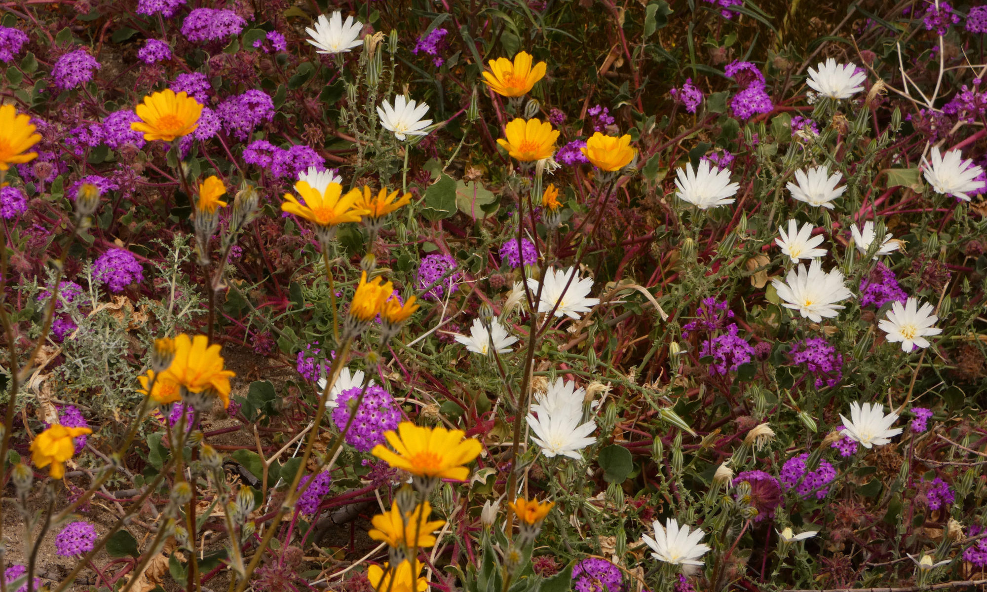
So what’s gonna happen with the desert wildflowers this year? People have been asking, so I took a quick little survey of my favorite spots so I could make an educated guess. Take it with a grain of salt. Things could always change. I remember one year at Death Valley when all the experts said it was grim, too dry, don’t expect any wildflowers this spring! Then we had the rainiest February on record. It was a lovely wildflower season.
There ARE a few teeny tiny seedlings coming up in Death Valley.
Sorry to say, unless something unexpected like that happens, it will be a rather poor wildflower season due to the La Nina weather conditions we have been experiencing.
La Nina weather patterns generally mean the southwest will be hotter and dryer than normal. The northwest will be wetter and colder. This winter we have definitely seen those conditions, as anyone bogged down in the rain in Washington or praying for precipitation in southern Colorado will verify.
The California desert is a tough place to live even in a good year. This year is downright brutal.
Ocotillo in Anza Borrego
Take Anza Borrego, for instance. Sorry, all the flowers bloomed last year and none are left for this year. Just kidding. There are other reasons why nothing is blooming, like heat and especially lack of rain. The state park has only received 1.1 inches of precipitation since July. There was a big storm in September in the mountains, but it didn’t even reach the valley floor. They did get one good rain in January, but it was not enough for the annuals to germinate. It’s already really hot, just under 90 degrees at the end of January. Those big fields filled with lilies, verbena and primrose last year are bone dry and dirt brown, with no little green things coming up. There ARE a few plants getting started in the far eastern reaches of the park. Word is some of the upper elevations are getting a few blossoms. Try Plum Canyon. The occasional ocotillo, brittlebush, or chuparosa (all perennials) are currently putting out a few blossoms, and they’re just getting started. You can depend on the perennials, even if the annuals take a year off.
If you are planning a wildflower trip here, make it early March and you may find more happening at the higher elevations. The valley is looking pretty dismal.
Bladderpod Mojave Preserve
Joshua Tree is suffering under the same conditions. Brittlebush, which I’ve seen blooming randomly everywhere else in the California desert, is looking dead here, worse than just dormant. Even the leaves are all shriveled up and brown. Ray of hope – I did see a bladderpod bush and an ocotillo with blooms. Don’t expect much from the flowers here this year, though.
Surprisingly, Mojave National Preserve is actually looking better than it did last year. I saw brittlebush and bladderpod blooming here. Little green things are creating a fuzz on the sides of the road. Last year I saw nothing.
Desert Gold in Death Valley 1/24/18
Death Valley is doing a little better. Little green seedlings are trying to get a foothold in many places. There were two storms in January here. You might call them scattered showers. Some parts of the park got a lot of rain, some none at all. The usual hotspots near Ashford Mill and the west side of Jubilee Pass are looking very sad. All dried out, no green coming up at all. The west side of Jubilee Pass through Salisbury Pass, all the way to the Greenwater Road, had a fine green fuzz on the sides of the road. Desert Gold was blooming from about MM21 through 26 on the Badwater Road, with a lot of little plants getting started. I did not see any Brown-Eyed Evening Primrose plants anywhere. This is usually one of the early bloomers. The seedlings are usually getting started by the end of January. Not a good sign.
The wind was relentless the entire time I was there, which will dry those tender little seedlings off in a hurry. Another rain could be the maker/breaker of the wildflower season here. Expect an average year, no massive fields of flowers as far as the eye can see, but there will be flowers. This is a year to contemplate the perfection of each individual bloom. Marvel over how tough these plants must be, to bloom and share with us their beauty in spite of only an inch or so of water for the entire year!
My bet for the best place to catch desert wildflowers this year is the Coachella Valley. Although this area is also suffering a lack of rain, I saw a few different plants blooming here – brittlebush, ocotillo, sacred datura, globemallow, even a patch of sand verbena. They were the early birds, few and far between.
Couldn’t ID this one – looks like a Senecio to me – any ideas?
I would wait a couple of weeks until late February or early March. I would recommend the trails in Sand to Snow National Monument. The monument hosts quite a lot of diversity in habitats, so you may find something blooming somewhere!
I recently drove Highway 1 in California, from Morro Bay to the Oregon border. I have got to say, hats off to the California Department of Transportation. Engineering this road was quite a feat, but it seems to me maintaining it is even more amazing.
Highway 1 is definitely one of the most beautiful drives in the country, but its very existence is quite precarious. And after a stormy winter like this one….
Mendocino Coast
In a lot of places it was a one lane road, where part of the road was devastated. There were four major closures on the highway, where both lanes were damaged too badly for any kind of an easy fix. If you saw where this road goes, you would be amazed that it is only four places.
Highway One hugs the coast, a fine line between the cliffs and the sea. It travels through an incredibly dynamic landscape, a land in flux.
The San Andreas Fault runs here. This part of California is trying to move to Alaska! And tectonics, although a big game-changer, is not the major force affecting this road. It’s erosion. Water.
One lane of the highway eaten away by the surf just north of here on the Sonoma Coast
Think about it. Steep cliffs, unconsolidated soils, a heck of a lot of rain. That means mudslides. Practically everywhere, all that water and soil is trying to take a trip to the beach. Hills are slumping, attempting to erase the road, a horizontal ribbon in this vertical landscape. Not only mudslides. Rock slides, too.
The mudslides are countless, and responsible for most of the closures, but the force that really amazed me was water coming from the other direction. The sea. Waves crashing against the cliffs. Powerful. Constant. Relentless. It’s truly awe-inspiring. Eating away the ground from underneath the highway continuously, little by little. The wild and mighty Pacific.
A few miles south of the Lost Coast
In some places where the road is down to one lane, you can see there is nothing left where the other lane once ran. It is amazing to me that this road still exists at all.
Highway 1 is an incredible road, one of the most beautiful and craziest roads you will ever travel. Do travel it. Soon, while you still can.