My Favorite Places

Stairway Icefall

This week I’d like to share with you all some of my favorite places, ones I will miss this winter as I practice The Middle Way on Orcas Island. This week’s Lens-Artist’s Photo Challenge is Home Sweet Home. Tina Schell of Travels and Trifles asks us, ” If a foreigner were to spend a week or a month traveling your home country with you, where would you take them? What sights would you tell them to be sure to see? Where have you found some of your own favorite images? What is it you truly love about where you live, or places you’ve seen in your home country? ”

Southern Colorado
First snow in the Colorado mountains

Well, they would need at LEAST a month for all MY favorite places.  Although I grew up in Colorado and now live in Alaska, I feel at home throughout the West. I’ll start with Colorado. I was raised in Colorado, and lived there for many, many years after I went out on my own. It’s probably where I’ll end up when I get too old to live deep in the wilderness in Alaska. My family is there. Colorado is always close to my heart.

Petrified Forest National Park

Although I’m at home throughout the West, I do have a few favorite places that I try to visit whenever I have the chance. One is the Colorado Plateau. This region covers big chunks of 4 different states: Colorado, New Mexico, Utah and Arizona. I can’t narrow my favorite down to just one or two places in this area, it’s all so amazing. My advice to a foreign visitor might be to check out a few places that are not as well-known as iconic parks like Arches and Zion. Although I love them, too, they ARE getting loved to death and it might be good to try to spread that impact out a little. Lesser-known places such as Grand Staircase-Escalante National Monument and Petrified Forest National Park contain wonders, too.

Colorado Plateau
Grosvenor Arch in Grand Staircase-Escalante

Another favorite place is Bosque del Apache National Wildlife Refuge in central New Mexico. This is the best place I’ve ever been for birds. It is the winter home for vast flocks of Snow Geese and Sandhill Cranes.  Over 340 different species of birds live there. It is an incredible place to observe wildlife.

Sandhill Cranes
Bosque del Apache National Wildlife Refuge

I spent 8 winters working as a ranger in Death Valley National Park. It is another desert that has captured my heart. The great thing about Death Valley is that because the altitude on the valley floor is so low (the lowest elevation in North America), the nights are seldom cold, even during the deepest darkest months of winter. Makes for great camping, and the rattlesnakes sleep in the winter! It’s an incredibly diverse park, with elevations ranging from below sea level to over 11,000 feet.

I did a little playing with LightRoom on this image. It was a daytime image and the background of bare dirt desert ground was a bit meh so I darkened it until it resembled the night sky, and tried to give a nighttime feel to the dunes, too. Since Death Valley is famed as a night sky park, and since one of my favorite things to do is to walk through the sand dunes under the full moon, I wanted to capture the feel of that experience in this image.

Mesquite Sand Dunes
I love to hike the sand dunes in the moonlight.

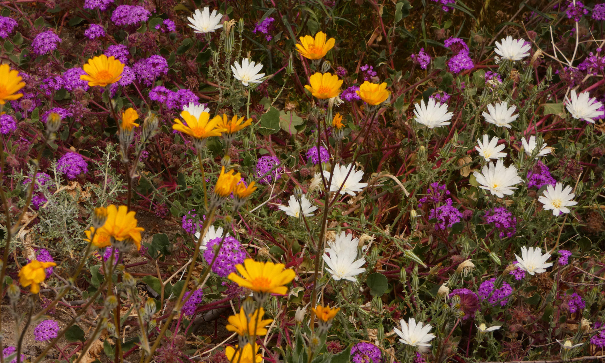
And then there’s the bloom. If there is rain in the desert, and if it is timed right, the wildflowers will rock your world. If it seems like it might be a good year for the flowers, I try to make a circuit that starts near the Mexican border in Anza-Borrego State Park, moving through Joshua Tree and Mojave National Preserve until I end up in Death Valley.

Anza-Borrego State Park
Love those desert wildflowers!

Further west on the California coast you will find another great wildlife phenomenon, the elephant seals at Piedras Blancas near San Simeon. Although you can find a few seals there at any time of year, December through February are the best months. Thousands of seals converge on the beaches, with the big strange-looking bulls battling it out for the right to own a piece of the beach, and all the females on it. The cows are birthing and raising their babies then, too. It’s an extraordinary spot to witness wildlife drama, so close you don’t even need binoculars to see it.

Piedras Blancas Elephant Seal Rookery
Sex on the Beach

From the campground at San Simeon I can walk to the beach and see some fantastic bird action on the sea stack that looms just offshore there. It’s an awesome place to catch the sunset.

Farther north along the California coast is Mendocino County. It’s my favorite part of the California Coast. I think the scenery is even more dramatic than Big Sur, and without the crowds. It’s got big trees, too.

Greenwood Beach
The beaches in Mendo are wild and uncrowded.

Speaking of big trees, I’ve really fallen in love with the tallest trees in the world, the redwoods, over the last few years.

Redwood National Park
Tall Trees

Sometimes I go straight up the coast into Oregon. Other times I head for the Siskiyou country near Grants Pass and Williams. The trees there are incredibly graceful and beautiful and it’s my last chance to see wildflowers as I head north.

Pacifica
Oregon has some incredible trees!

But no matter which way I go, I try to hit the coast at Bandon. It is so much fun to shoot the sea stacks there!

Bandon, OR
Sea stacks at Bandon

The Olympic Peninsula is my next favorite place. The old-growth forests redefine green and the wild beaches are phenomenal.

Olympic National Park
Ferns and feathers

And then there’s Alaska. It’s where my heart is, my community, my job, my life. My first love in Alaska was Denali National Park and I try to go there whenever I get a chance.

Dall's Sheep
I love Denali!

But home is McCarthy, in Wrangell-St. Elias National Park. I truly believe it’s the most spectacular place in North America. Case in point – check out my daily commute! And the feature image was taken while I was standing on my front porch! It doesn’t get much better than this.

Wrangell-St. Elias National Park
My daily commute to work

I hope you’ve enjoyed some of my favorite places. As Jim Morrison of the Doors said, the West is the best!

Strange Sights on Desert Highways

Highway 60, NM

It’s a long way between towns in the desert, and sometimes the road seems endless and lonely. I love those far lonely drives, so I wouldn’t call it monotonous, but I do have to admit that there are big stretches where nothing especially stands out.

It seems that when there is a lack of natural landmarks, people feel compelled to fill in the blanks. Occasionally strange, off-the-wall objects spark up the view in those empty miles. I decided to write about a few of them for this week’s Lens-Artists Photo Challenge: Interesting Objects. 

Very Large Array
They’re listening. Is anybody out there?

Highway 60 in New Mexico is one of those highways. Towns are 20, 30, 40 miles apart. And when you do reach a town, don’t blink or you’ll miss it. But there are a few things out there that can shake you out of your highway trance.

One is the Very Large Array, a couple of miles east of Datil. It’s a radio telescope facility. Astronomers use radio waves to capture light in other spectrums and waves besides visible light, giving them a much more complete picture of what’s out there in the Universe than we could see if we just used visual information. The landscape is littered with humongous dish antennas, set out in a long, long line as far as you can see on either side of the highway.

Highway 60, New Mexico
Rural Outdoor Art

A little farther west I came upon this interesting collection of windmills. There were a couple of mannequins included in the display, I guess to give a sense of scale.

Catron County is popular with hunters. In the town of Quemado, I found a Christmas tree made out of deer antlers.

Quemado, NM
Merry Christmas?

When I drove through Arizona this year, it felt more like the Wild West than it ever had before. I’ve driven through the state many times, but never before have I seen so many signs and storefronts offering guns for sale.  I live in Alaska, a state where most households own firearms, so I understand folks exercising their right to bear arms, but this year in Arizona it was over the top.  It seemed a bit hysterical.  I believe those folks are convinced Armageddon is coming. Or they want to help bring it on. In Wikieup, I guess maybe guns are not enough. They’ve got rockets!

Wikieup, AZ
Arizona likes its weapons.

One of the loneliest stretches of highway out there is California Highway 62, between Joshua Tree and the Arizona border. Suddenly, in the loneliest bleakest part of the road, you come to a few burnt-out foundations and crumbling walls surrounded by a broken-down barbwire fence. The fenceposts are decorated with sneakers, thousands of them. They’re mostly sneakers, but there are a few other shoes and gloves included in this bizarre display. Why did this site become the West’s athletic shoe graveyard? I have no idea.

Highway 62 CA
Another rural art installation. This one is anonymous and interactive, kind of like graffitti.

These are only a few of the many strange and interesting objects to be found along those lonely desert highways. Maybe you have a favorite that I haven’t mentioned. Share it with us in the comments.

Thank you, Patti, for hosting this week’s photo challenge.Highway 62, CA

Let’s Get Wild! Lens-Artists Photography Challenge #150

Denali National Park

For this week’s Lens-Artists Photography Challenge, let’s get wild!  I’m talking about Mother Nature untouched and untrammelled,  allowed to get on with her work without human help or hindrance.

“Those who contemplate the beauty of the earth find reserves of strength that will endure as long as life lasts.”

Rachel Carson
Denali National Park
Everyone can find some wild to get close to in their life, even if it’s only a flower.

Maybe you’re lucky and have access to some truly wild landscapes. Perhaps you’re not. But give her a chance, and Nature will break free and get wild wherever we let her! Even if your only access to the natural world is the local park, you will certainly find something wild in your world. It could be a bird migrating through on its way north and south, or a wildflower springing up on an empty lot.

I don’t want to see groomed gardens or animals in the zoo. No people or signs of people. I want to see and revel in the natural world in your posts. Where’s the wildest place you’ve ever been? Where do you go to let Mother Nature regenerate your spirit? Please share with us the wild places, plants and beings that are close to YOUR heart!

But love of the wilderness is more than a hunger for what is always beyond reach; it is also an expression of loyalty to the earth which bore us and sustains us, the only home we shall ever know, the only paradise we ever need – if only we had eyes to see.”

Edward Abbey
Wrangell St. Elias National Park & Preserve
Life in the Wrangells, gateway to the wilderness

The natural world is my passion in life, and I love to share it. A long time ago I decided the most important goal in my life was to wake in beauty every day. Because I’ve made that a priority, I’m more fortunate than most when it comes to being close to nature. With a telephoto lens, this is the view from my bedroom window.

The price for that view is no running water or indoor toilets, and the hard work and logistical challenges of attempting to maintain an off-the-grid homestead. But it’s a price I’m happy to pay, because every morning when I wake up, the angels sing!

I live in the center of Wrangell-St. Elias National Park & Preserve in Alaska, one of the biggest protected wildernesses on the planet. But these days I usually snowbird it and go south in the winter. There are too many beautiful places in the world to spend your life in just one, no matter how wonderful that one is.

I migrate, like the birds.

I used to be a ranger in Death Valley National Park, which has more wilderness than any other national park outside Alaska. Pretty easy to find the wild there.

A nameless canyon in Death Valley National Park

My favorite way to get next to the wild is to get up close and personal with wildflowers. Drop down to their level. Breathe in their fragrance. Get out a magnifying glass to really check out the intricacies of the tiny flowers. Revel in their beauty, but don’t pick them. Leave them living, so others will have a chance to appreciate them, too. I spend March and April most years following the wildflower bloom, first in the desert…

And then catching the spring flowers in the Sierras and Oregon on my way back to Alaska.

And then there’s the sea. Another way to get close to the wild in the world. I have really fallen in love with the seashore in the last few years. What could be wilder than the ocean?

The ocean is so wild it’s like another planet!

“Wilderness is not only a haven for native plants and animals but it is also a refuge from society. It’s a place to go to hear the wind and little else, see the stars and the galaxies, smell the pine trees, feel the cold water, touch the sky and the ground at the same time, listen to coyotes, eat the fresh snow, walk across the desert sands, and realize why it’s good to go outside of the city and the suburbs.”

John Muir
We need to learn to share!

Wild places are important because we need to learn to share our planet with everything else that calls it home. It does not belong to us exclusively, although we all too often act like it does.

Wild places are also important because they rejuvenate our souls. Wilderness is essential to our mental health. What a sad world it would be if we had no wilderness. Celebrate the wild in the world this summer, and please protect it wherever you may find it!

“…the word of the Lorax seems perfectly clear. UNLESS someone like you cares a whole awful lot, nothing is going to get better. It’s not.”

Dr. Seuss
Celebrate and care for the wild in your world!

Please join me in this Lens-Artists Photo Challenge and share the wild in your world. Remember to use the lens-artists tag and include a link to my original post.

Next week, Patti will be offering LAPC #151, so be sure to check out her site then!  Her theme is From Large to Small.  Pick a color and take several photos that feature that color.  Start with a photo of a big subject in that color (for example, a wall) and move all the way down to a small subject in that same color (for example, an earring).

Thank you to Tina, Amy, Ann-Christine and Patti for inviting me to host this challenge. It’s wonderful to be part of the Lens-Artists community and I look forward to seeing all your wonderful wild posts this week.


But Oh! The Colors – Death Valley Rocks!

Golden/gower Loop, Death Valley National Park

The very first time I saw Death Valley the first thought that popped into my head was “Boy, but this is a barren landscape!” But right on the heels of that thought came a second, this one attached to a sense of wonder – But Oh! The colors!

Death Valley
I called this viewpoint “Better than Zabriskie”. It was my personal meditation spot. Only a ten-minute walk from the road and less than half a mile from world-famous and hopelessly crowded Zabriskie Point, I found it while exploring a little wrinkle in the landscape and was the only one that knew it was there. A great place for solitude on a busy holiday weekend!

So this week I’d like to share a different kind of rock art with you, Mother Nature’s masterpieces. I’m going to get a little artsy-fartsy and share some abstract photography, portraits of those fantastic colors, patterns and texture that can be found in every corner of the national park.

Death Valley National Park
A glimpse of the Last Chance Range

I’m convinced that every color of the rainbow can be found somewhere in Death Valley’s rocks. I’m so convinced that when I was a ranger there, I played a little game as an icebreaker, to slow my visitors down on my Nameless Canyon hikes and sharpen their powers of observation. I picked up a random assortment of paint sample chips at the hardware store. I included lots of variety – purples, blues, yellows, pinks, browns, tans, greys – no two colors exactly the same. It was a big box hardware store. I got LOTS of paint chips.

Artist's Drive Formation
Pinks and greens and yellows…

Then I cut them all to a uniform size and put them in a bag. Each hiker had to blindly thrust their hand in the bag and pull out three paint chips, then find its EXACT match in the landscape we traveled through.

Zabriskie Point
It’s not only the colors, it’s the patterns and textures that make Death Valley’s rocks so fascinating.

There was a lot of eye-rolling and exclamations of “I’ll never find THIS color!” I did end up removing 2 or 3 shades of blue and one particular red chip. True black was a surprisingly difficult color to find. But nearly every time, each hiker would eventually find all 3 of their colors, no matter what they picked out of the bag.

Ubehebe Crater
Orange is the predominant color at Ubehebe Crater. Although the crater was formed by volcanic action, this orange rock, surprisingly enough, is sedimentary.

Some areas are more colorful than others, world famous for their colors, it’s true. But even the hills that look a uniform baked brown from the road reveal their loveliness in the layers and shades you will find if you get a little closer.

Kit Fox Hills. Death Valley National Park
The shimmery glow of “candle drippings” in the Kit Fox Hills. Candle drippings are mineral runoff on the canyon walls that sometimes builds up into elaborate patterns, Mother Nature’s tapestries.

When you delve deeper, all those colors, layers and patterns reveal a plethora of geologic events and eras. If only the rocks could talk, what stories they could tell!

Mosaic Canyon
Noonday Dolomite, the “marble” that makes Mosaic Canyon such a fun hike!

So it doesn’t matter if it hasn’t rained all year. It doesn’t matter if it’s a poor flower year, or the wrong season. You can visit this national park and still see a brilliant display of color, because Death Valley rocks!

Death Valley National Park
Crazy swirly mountainside in the Funeral Mountains

Thank you, Ann-Christine, for bringing us this week’s Lens-Artist’s Photo Challenge, “You Pick It”.  Also thanks to Tina for the art inspiration and Amy for the desert rocks inspiration.

Monarch Canyon, Death Valley National Park
Beautiful warped and twisted stone from Monarch Canyon in the Funeral Mountains


Geometry in Ages Past

Mesa Verde National Park

When I saw that this week’s Lens-Artist’s Photography Challenge was geometry, I was at a bit of a loss at first. After all, I do primarily nature photography and although Mother Nature loves a circle or a sphere, she isn’t much into squares and cubes.

Colorado Plateau
Trapezoids, circles and ovals

Then I happened to notice a similarity in the rock art of many of the ancestral peoples of the desert southwest. These folks were really into geometry! Even their sheep were made up of squares and rectangles.

Three Rivers Petroglyph Site
Squares and circles on this petroglyph from Three Rivers Petroglyph Site in New Mexico.

Stylized, geometric depictions of people and animals can be found in rock art from the Fremont culture of northern Colorado and Utah to the Ancestral Puebloans of the Four Corners region to the Mogollon culture of southern New Mexico and Arizona.

Mogollon culture
Rectangles and squares – These ruins at Gila Cliff Dwellings National Monument in southern New Mexico date back to the 1200s.

Most of the ruins and rock art date back 700 to 1100 years. There are thousands of sites throughout the canyons of the desert southwest, some in quite remote locations. It is so thrilling to walk around a bend in a canyon and discover these traces left behind by people who lived there a thousand years ago!

Petroglyphs
Rock art panel near Moab, Utah

My first backpacking trip into the desert was in Grand Gulch, Utah. Back then it was just BLM land, in the middle of nowhere. Now it is part of the disputed Bear’s Ears National Monument.  After walking around many bends in the canyon and discovering rock art and ruins here, there and everywhere, I was hooked for life. Searching out Ancestral Puebloan sites on the Colorado Plateau became a hobby and a passion of mine every spring.

Dinosaur National Monument
The trapezoidal body shape of this petroglyph is typical of Fremont Culture rock art.

By the end of the 1800s, many ruins were damaged and destroyed by pothunters, who would tear up the dwellings in their search for the buried treasure of the artifacts left behind. In 1906 the Antiquities Act was passed by Congress to protect these national treasures.

Petrified Forest National Park
Agate House in Petrified Forest National Park was built out of petrified wood.

Since then, only 5 presidents have not used the Antiquities Act to protect additional lands (Nixon, Ford, Reagan, Bush Sr. and Trump). Trump is the only president who has attempted to remove lands from Monument status.

Ancestral puebloan rock art
Many rock art panels have been defaced by bullet holes and graffiti

Theft and vandalism are still major problems faced by those trying to preserve both ruins and rock art. When I worked at Death Valley, we were not allowed to publish any pictures of rock art in the park or disclose locations to visitors because people would literally chip the panels right off the cliffs!

Dinosaur National Monument
Rectangles and circles on this rock art figure from Dinosaur National Monument

Graffiti and target practice deface many rock art panels. This damage is difficult and often impossible to repair. I can’t help but wonder why some people feel this need to destroy the work left behind by others. I just don’t understand it.

Thompson Utah pictograph
Triangles – Why would someone deface a painting that had lasted a thousand years?

Since enforcement is so difficult, the key may be education. If we can convince others of the value of these ancient artifacts, and how that value is enhanced by being left in place for future generations, perhaps we, and our grandchildren’s grandchildren, may enjoy the geometry of ages past for many more years to come.

Fremont Culture
Rock art in Dinosaur National Monument

Thank you to Patti of pilotfishblog for this week’s Challenge, Geometry.


An Unusual Occurrence – Death Valley Rain Events

Badwater Salt Flats

A rain event in Death Valley is a very unusual occurrence. After all, it IS the driest place in North America. With only about 2 inches of precipitation a year, rainstorms don’t happen very often. Rain events are even rarer.

I worked at Death Valley for 8 winter/spring seasons. In that time, I witnessed 2 rain events.

  • Death Valley National Park
    Standing at the mouth of Titus Canyon watching the first rainstorm of February 2010 come in over the Panamints

A rain event is much more than just a rainstorm. it has long-lasting repercussions. It can totally transform a landscape, and those transformations are part of the event. These are indeed special moments.

Death Valley National Park
Badwater Salt Flats after the first storm

My first rain event was in 2010. During the winter of 2009/2010, it didn’t rain at all. All the oldtimers said it would be a poor flower year that spring. Too dry.

Mesquite Flat Sand Dunes
I spent a lot of time hiking the sand dunes that February because there were many times that the canyons were too dangerous. It rained and rained and rained.

Then February came, and with it, a series of Pineapple Express storms. A Pineapple Express is an atmospheric river formed above the ocean waters near Hawaii. Coming from the south, they dodge the high Sierras, leaving them with plenty of water to dump on Death Valley. We got 3 storms in a row. That February we received an inch and a half of rain. It was the rainiest February in Death Valley’s history.

Mesquite Flat Sand Dunes & Grapevine Mountains
The sand dunes were transformed into a desert oasis.

It was so wet that pools formed in the sand dunes, the only time I ever saw that happen. It looked like a true desert oasis.

Grapevine Mountains
Alpenglow on the Grapevine Mountains reflected in an ephemeral pool

The biggest change, though, was the Badwater Salt Flats.  The salt flats were transformed into a lake, filled with about 7 inches of water for miles in every direction. There was so much water a friend went kayaking just for the photo op. With all the fresh snow on the Panamints, this symbol of the driest of deserts became almost alpine in appearance.

Badwater Salt Flats
The lake at Badwater – deep enough to kayak.

The oldtimers still predicted a poor flower year, though. They said the rain came too late and there wouldn’t be time for the tender seedlings to get a good start before it became too hot.

They were wrong.

Notchleaf Phacelia
2010 turned out to be a good flower year after all.

My second rain event was the big one, a historic one, the great flood event of Sunday, October 17, 2015. It destroyed half the highways in the park. Scotty’s Castle is still closed due to this rainstorm.

It was literally my first day back to the park for the season. I needed to go to Pahrump, the nearest town, 60 miles away, to stock up since I was just moving in. It had been raining off and on for 2 days. My boss told me to be careful, there was flash flooding down by Death Valley Junction.

Badwater Salt Flats
Badwater in early December 2015

I made it through the water at that low spot alright, but that afternoon the storms came back in with a vengeance. I could hear the radio reports as I shopped, the calamitous beeping that heralded a severe weather alert. When I walked outside, I could see the blackest sky ever out towards the Northwest, contrasting sharply with the brilliant flashes of dozens of lightning strikes.

I tried to hurry home.  Things were starting to look serious. I knew I had to hustle to make it before the road was closed at Death Valley Junction. It had started raining, hard, and the thunder and lightning to the Northwest was truly something to behold. A light show, Fourth of July fireworks! I’ve never seen so many lightning strikes. I thought to myself that I was glad I wasn’t at Scotty’s Castle. Things looked really bad in that direction.

Death Valley Buttes
Storm over Death Valley Buttes

But they were bad enough where I was. Would I make it in time? The road started to get sketchy. I could see the edges crumbling and I knew for safety’s sake I had to try a different route. They closed that highway less than 10 minutes after I turned around. More than the edges had crumbled.

I thought I’d go the long way around, up north towards Beatty. I was stopped by the sheriff. That road was out, too. I ended up spending the night with a friend, a woman I worked with who lived in Pahrump.

Badwater Road
Badwater Road and Telescope Peak January 2016

We headed out in caravan to reach the park early the next morning, in radio contact with the park maintenance crew. There was one route that just might work. There was lots of water running on the road as we crossed washes. One crossing was doubtful. I could feel my little truck slow down and threaten to stall out. I was really glad we were caravaning. In hindsight, I wouldn’t cross water like that again. Within half an hour of when we went through, that road closed, too. But we made it.

The October monthly precipitation average for Death Valley is .07 inches. Death Valley received 1.3 inches of rain in October 2015, nearly all of it from the October 17 storm. That storm caused a lot of destruction to man-made structures and roads. But it also made some amazing changes to the landscape.

Greenwater Road
Imagine the ground growing thick like this with flowers – everywhere – for miles upon miles

Of course, Badwater Basin once again filled with water. No kayaking this time, though.  By the time the road crew had cleared and repaired the road as far as Badwater the water levels were already down too far for that. Mud and debris flows trashed the Badwater Road. The southern part of the road was completely destroyed, the pavement twisted and shredded.

The change that impressed me the most, though, was at Artist’s Drive. A debris flow had completely inundated the main canyon, filling it brim to brim and splashing ten to twelve feet up the walls in places. This layer of mud is now a permanent part of Death Valley’s geological record, a layer of rock that will still show up thousands of years from now. I love to see geology happen!

Artist's Drive
The main wash in Artist’s Drive filled brim to brim, overflowing with mud from the debris flow.

And then, starting as early as the end of December, the flowers came out. And continued to come out, month after month, all the way to May. They were so thick on the ground you couldn’t take a step without trampling a flower. And they were all supersized, too.

For instance, Desert Five-Spot is usually a shy flower; the plant grows about 6 inches high, with only a few blossoms on each plant. In dry years, it will dwarf into a tiny belly flower only an inch or two high with one blossom. But during the 2016 Death Valley superbloom, I found a veritable plantation of five-spot bushes, all about 3 feet high with dozens of blossoms. One plant had 53 flowers! What a difference a little rain makes!

Death Valley Superbloom 2016
Desert 5-spot

Although the Artist’s Drive debris flow was the most thrilling change for me intellectually, the wildflower bloom is what struck my heart. It was the ultimate of all the special moments I’ve experienced in my Death Valley rain events.

Thank you, Tina of Travels and Trifles, for this week’s Lens-Artists Photo Challenge, Special Moments.

Death Valley Superbloom 2016
Alpenglow on the Black Mountains behind a field of Desert Gold