I’m in the middle of the long dark now. The sun barely rises by 10:00 AM. Then a few minutes after 3:00, it’s already setting. I’m definitely feeling the effects of SAD syndrome. It feels like the long dark night of my soul, too.
Crimson Columbine
The weather this week doesn’t help. It’s cold, windy, grey, gloomy, rainy, sleety, icy – pretty much everything I dread about winter in Alaska. It feels like the grimmest month of the grimmest year of my life.
Sparrow’s-Egg Ladyslippers
I need to escape. Most winters I can do this physically, like birds and whales, overcoming the dark and dreariness by heading south and avoiding it altogether. Due to Covid, that really wasn’t an option this year.
Lupines
But there is a way out. A way to make my winter escape. I can travel in my mind, trading the monochrome greys outside my door for brighter, happier shades, traveling back in time through my photo files to the vibrant colors of summer wildflowers in the Wrangells.
Round-Leaved Orchid
“Opportunities to find deeper powers within ourselves come when life seems most challenging.” – Joseph Campbell
Wild Roses along the McCarthy Road
Perhaps you too are feeling the drain from this long dark scary winter. Is the adversity and uncertainty so many of us are experiencing right now getting you down, too? Join me then on this journey in my mind, a winter escape to a bright and peaceful land filled with the ephemeral beauty of my favorite subject, wildflowers.
I’d like to share a quiet moment I recently had on the McCarthy Road. I was chasing rainbows, looking for them, knowing the light was right. Trees blocked my first glimpse, but if I could make it to the pond before it faded…
I caught the tail end for just a few seconds before the shower came back and blocked the sun.
Caught the last glimpse
Usually, this spot is all about the birds. It’s a favored Trumpeter Swan nesting place most years. But this year it’s the flowers.
Swan & Cygnet
I was hunting for orchids. They love that moist mossy patch of roadside. I hoped I’d get lucky and spot one or two. What I found was a whole hill just covered with them. (I wished I’d brought a better close-up lense.)
The Roundleaf Orchids were my favorites. I guess you might say the Roundleaf Orchid is a quiet flower. Like some people I know. Tiny belly flowers, easy to overlook, but if you really focus on them, a priceless treasure.
Roundleaf Orchids
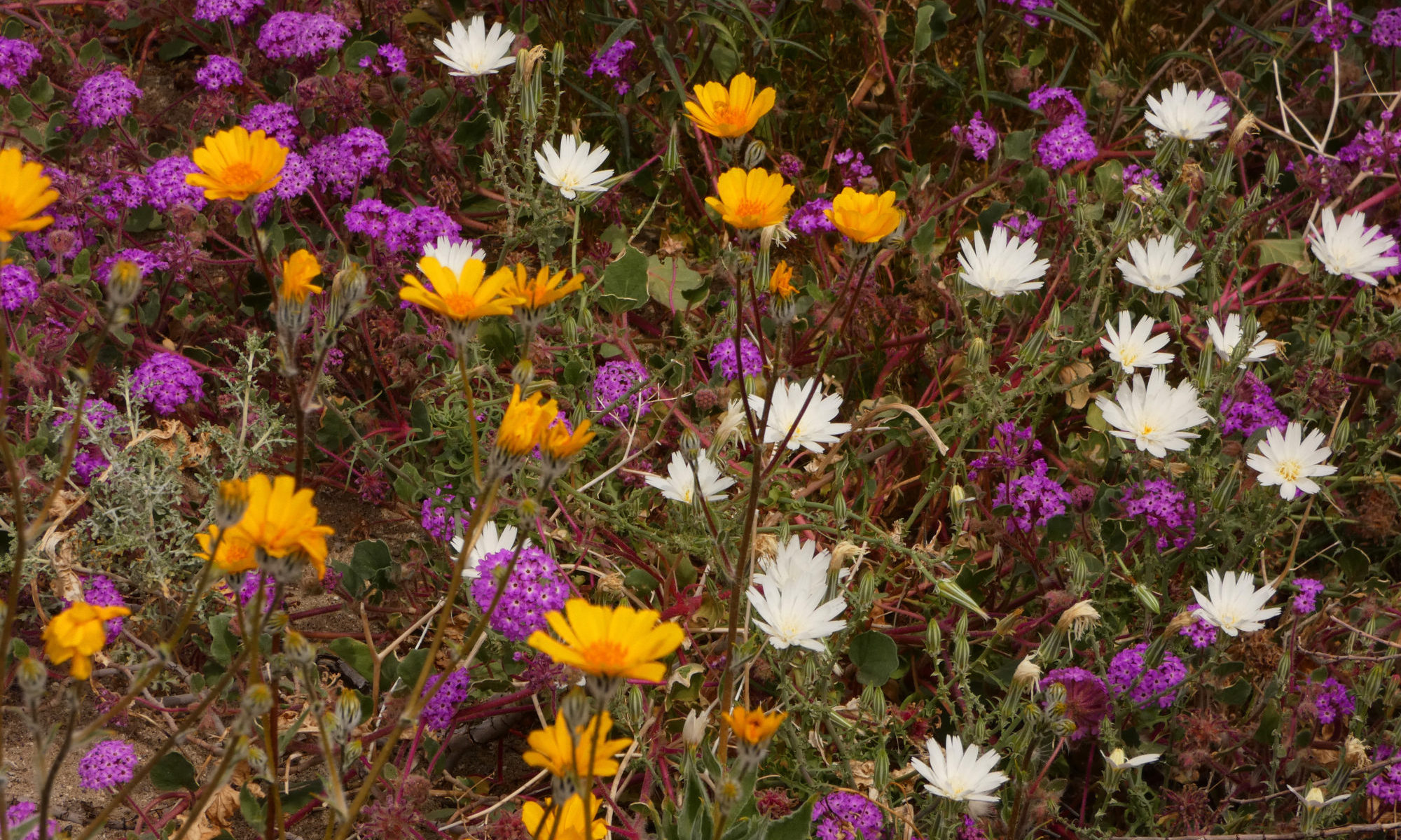
There were other flowers, too, over a dozen different varieties. Not big fields like a Mojave Desert superbloom, but scattered here and there through the grasses and the willows.
But I guess it wasn’t a quiet moment after all. A symphony of birdsong filled the air. It was more of a peaceful moment.
Lupines
What was quiet was the road. I stopped for at least 20 minutes and not another car came by going either direction. On solstice weekend!
It reminded me of the old days, before the rest of the world discovered McCarthy, when it was never-never land.
The hillside was covered with orchids!
It’s pretty quiet in McCarthy so far this season. There are a few visitors, mostly fellow Alaskans, but no crowds. I like that. It’s the tiny silver lining in the increasingly black cloud of our present-day reality.
But this quiet moment definitely feels like the calm before the storm. Travel restrictions have been lifted. The 4th of July will bring a huge influx of visitors.
Sparrow’s Egg and Roundleaf Orchids
Alaskan villages are haunted by the specter of the last epidemic, the 1918 flu epidemic. Alaska was one of the places hardest hit by that scourge. It completely wiped out entire villages. And it wasn’t the first wave that got ’em, it was the second.
The first wave hasn’t even hit here yet. It could happen again. We’re very far from medical care.
Quiet days in McCarthy
But this is also a town with an economy based entirely on tourism. What is the balance between economic survival and the lives of others in your community? That is the question that our village, along with the rest of the nation, is wrestling with now. Even in a community as remote and close-knit as ours, neighbor is pitted against neighbor in this struggle between economic prosperity and keeping people safe.
Personally, I feel that the lives of my friends and neighbors are priceless, much more priceless than that beautiful roundleaf orchid. They’re worth taking a few precautions for, making a few sacrifices.
McCarthy
If you love McCarthy, maybe for this year’s Fourth of July you might consider giving us a pass and recreating closer to home. If you must come out, do your best to keep us safe. Avoid the crowds. Keep socially distant. Please, please wear a mask. It’s not about politics, it’s about being considerate to others and not passing on a deadly disease that you’re not aware you’re carrying. It’s about keeping all of us here for each other for just a little while longer. Take a quiet moment and think about our community, which like that orchid, is so beautiful but so very fragile.
Thank you, Patti of Pilotfish, for this Lens-Artists Photo Challenge. I’m a day late and a dollar short due to connectivity issues, but better late than never.
I thought I was used to driving on narrow roads. After all, I live at the end of the infamous McCarthy Road in Alaska.
The McCarthy Road
The McCarthy Road has a reputation. It used to be considered the worst road in Alaska. Barely over one lane wide, the road had features like Hug-A-Boulder Bend, a dangerous blind corner.
The Kuskulana Bridge, a remnant of the old Copper River & Northwestern Railway, was another challenge. When it was built in 1910 the Kuskulana Bridge was the 17th-highest bridge in the United States.
Kuskulana Bridge
Thirty years ago, the Kuskulana crossing was just a couple of planks wide with no guard rails. Imagine crossing then, with the river over 200 feet below and nothing to stop you if you misjudged the width of that plank! People used spotters to make sure their wheels stayed on the boards while crossing this perilous chasm. Most people turned back.
We still had Hug-A-Boulder Bend when I moved to McCarthy, but the Kuskulana had been upgraded to a full one lane. With guard rails! The road still had a reputation, though, for potholes, mudslides, and railroad spikes turning up in people’s tires. It would still take a good 3 to 4 hours to travel its sixty miles. In the summertime. On a good day.
Times have changed. Hug-A-Boulder Bend is no more, blasted away, no longer a safety hazard. The road is wider, mostly 2 lanes now. Part of it was chip sealed, which actually made it worse when the frost heaves hit after the first year of smooth sailing. Although flats are still common, nobody finds spikes in their tires anymore. The road is graded more often, although it still can get a bit rough due to potholes, mudslides, and beaver dams. These days it only gets really bad in the winter. But it would still be considered narrow by most folks.
The McCarthy Road is still potholed and narrow.
The Denali Park Road
Another narrow road I know well is the Park Road in Denali National Park. I drove this road frequently when I worked as a ranger there for a couple of summers. Sections of the road are so narrow and hazardous that a driver needs to pull over at the wide spots to scout the upcoming curves and wait for approaching traffic. You have to go through a training session before you are allowed to drive on this narrow road.
That road is even narrower now. It is literally sliding right off the cliff because of melting permafrost. Last summer heavy rains exacerbated the problem. Mudslides stranded about 300 visitors for a couple of days until road crews could clear the debris. This summer the narrow road may not be open at all past Mile 41 as park and highway personnel search for a longer-term solution for the worst section.
The Denali Park road may be closed this summer due to geohazards caused by permafrost melting.
I thought I was used to driving on narrow roads. But this winter’s travels have put a new spin on narrow for me.
Northern California Coast Roads
This month I’m housesitting on a narrow, winding road in Mendocino County, California. I have to slow down to 20 mph for the last half mile, then completely stop and throw the truck into first gear to negotiate the steep hairpin turn into the driveway. The road is so narrow that turning out of the driveway takes both lanes and I still nearly hit the massive redwood on the other side of the road every time I leave the house. The convoluted terrain along the northern California Coast means most of the roads around here are like that, extremely narrow and squiggly.
Like Denali, geohazards such as mudslides and roads falling off cliffs complicate matters here. Some of the ways climate change impacts these roads include rising sea level and increased severity of storms.
Take a sharp left switchback at the mailboxes.
These narrow roads all feel like four-lane highways, though, when compared to the Bursum Road. This New Mexico road leads to the tiny mining town of Mogollon.
The Road to Mogollon
This is Gila River country. the mountains where Geronimo and his band lived. I can understand why he was the last chief to surrender. It’s incredibly wild terrain; challenging, rough and remote. The first time I traveled in these mountains I learned to respect just how rough and remote they could be. This year’s travels made me respect them all the more.
Mogollon is kind of a ghost town. A couple of the old buildings have been refurbished into summer businesses, and a few residents live there year-round, but walking through on a winter’s day, you probably won’t see another soul.
Which is a good thing. I certainly wouldn’t want to run into anyone coming the other way on most of the Bursum Road. It’s a one-lane road hung on the edge of a cliff, and it’s relentless. It’s a long way in between spots wide enough to pull over enough to let another car pass in the opposite direction and it’s one blind curve after another for miles and miles. It was the scariest road I’ve ever driven.
The road to Mogollon is dangerous and scary!
I couldn’t find a spot wide enough to turn around safely. I was praying, “Please let me survive this. Please, don’t let there be anyone coming the other way. I promise I’ll never come here again. This trip is not worth my life.” Just to make it even more challenging, the late afternoon sun was in my eyes on the way out. The prayers changed to “Lord, please don’t let me drive over a cliff.”
I was lucky. No one was coming the other way until I crossed the cattle guard and hit a wider pavement and safety. Right then I passed a big pickup pulling a trailer full of mining equipment headed to Mogollon. If I had left less than 5 minutes later I would have run into him at the most hazardous curve on the road. Perfect timing! Whew! The Universe heard my prayers! The Bursum Road was the scariest road I had ever driven.
I didn’t take any pictures to show you just how scary it is. There was nowhere that felt safe enough to stop. But here’s a link if you want to travel this road virtually. It’s the only paved road I’ve ever traveled that I wouldn’t drive again because I feel the risk is too great. This is one scary road.
A Little Advice
Some advice for folks traveling narrow roads, wherever they may find them. SLOW DOWN around the curves!! PLEASE slow down. Someone might be coming the other way and on most of these roads, you’re a long way from help. Just sayin’.
Fall is my favorite season in Alaska. All of the color and none of the mosquitoes! This fall I took a few little trips up north, trying to catch the colors on the tundra.
Finger Rock, Dalton Highway
My timing was not the best. We had a late spring this year, which led to a late fall. I expected a lot more color way up north on the Haul Road than I actually found there. But there were bits and pieces.
I had the same problem when I drove the Denali Highway Labor Day weekend. You know when you mix green and red when drawing or painting and get a muddy brown hue? That’s pretty much what I found in the Tangle Lakes area. In other years, I’ve come through around Labor Day and the colors were peaking or past the peak. Global climate change or just an off year? Things got better after I crossed the Susitna River.
Denali Highway
Continuing north to Denali National Park, I couldn’t believe what I was seeing. The aspens had not even begun to turn! The tundra was the same muddy mixture of green turning red that I’d found in the Tangle Lakes area. What a disappointment! Most years the colors start by mid-August in Denali.
There WERE occasional spots of brilliance on this trip, but not a lot.
Aspens in Chugach National Forest
I even drove over Hatcher Pass, only to find more of the same. Not the most colorful Alaskan autumn I’ve ever seen.
Another challenge on these trips was the weather. It was the rainiest August I think I’ve ever experienced, raining practically every day for the entire month.
September was a different story. It was one of the most fabulous Septembers I’ve ever had the joy to experience in McCarthy. Sunshine nearly every day. It was brilliant!
Gilahina Trestle
I had to stay close to home for most of the month, so instead of the brilliant reds and oranges of the tundra, this year was all about the golden hues of aspens, willow and cottonwoods in the lower elevations. I had to turn to fireweed and roses for my red and orange fix.
Fall rose leaves
The leaves have fallen now. Alaskans have to look to the sky for their color fix now, to the brilliant hues of the aurora. But I’m following the fall. I’m now in the Pacific Northwest, where autumn is just beginning. Lucky girl, I get to do it all over again!
I love the McCarthy Road. The road drifts east 60 miles from Chitina to McCarthy, a tangled dance of Park, private, Native and State lands. It’s a bit on the raw side. If you make it in 2 hours, you had a very good day. Most days it takes about three.
Wrangell Mountains in the Sweet Light
I don’t think I’ve ever made it in 2 hours. I like to take my time. It helps me make the transition from laid-back McCarthy to the modern world.
It used to be called “the worst road in Alaska”. The first year I was here, every time my friend Jill drove the road, another part fell off her car. After 2 summers of losing pieces, she was done. Back then, travelers understood that the journey was just as important as the destination. A trip down the McCarthy Road was an adventure in itself.
Leaving Chitina, you pass through a one-way cut, remnants of an old railway tunnel. It’s a kind of gateway, your first clue that the McCarthy Road is a different kind of drive. Around the corner, you get your first glimpse of BIG water, the confluence of the Chitina and Copper Rivers. It’s the 10th largest river in the U. S. in volume and the only river in Alaska that’s longer is the Yukon.
Copper and Chitina River confluence in early spring
The Copper is famous for its fishery. Copper River Red salmon is regarded as one of the finest salmons in the world. At the bridge is a State subsistence fishery, so people come from everywhere on Alaska’s road system to try their hand at dipnetting for some prime fillets and a few fish to can or smoke for the winter. Upstream you can look past a jumble of local fish wheels to the glowing snows of Mt. Drum.
Summer sign for the MXY Road
Cross the Copper and there’s the sign. It’s a warning sign – Are you SURE you’re ready for the McCarthy Road? The sign is a lot more severe in the winter “Travel on this road is NOT recommended. Expect avalanches, road glaciers, extreme cold…” Be prepared for any eventuality. You’re a long way from nowhere.
Right after the sign, the road climbs the Kotsina Bluffs, a microcosm of future challenges. The washboard on the way up the hill will rattle your parts off. Skinny road, steep cliff, no guardrails, and mudslides sloughing off the hill to the right.
Kotsina Bluffs
The Kotsina River has recently changed course, crossing its broad floodplain to erode the bottom of the bluff directly below you. Look for the half-buried RV near the Copper, stranded and then inundated when the Kotsina made its sudden detour. But maybe you’d better keep your eyes on the road, watching for potholes, falling rocks, or oncoming traffic around the next curve.
At the top of the bluff, you hit the chipseal. A few years ago, the DOT chipsealed most of the first 17 miles of the road, from the top of the bluffs to the Kuskulana. We warned them this wasn’t the best idea. Within a year it was a minefield of horrendous potholes and frost heaves so bad that entire sections of road had just fallen away. The “improvements” haven’t changed the character; you still have to pay attention.
Chitina River
After a few miles, pull over for a scenic view of the Chitina River. I get a warm fuzzy feeling when I look at that vast wilderness upstream and realize I’m going into the heart of it.
Ponds along the McCarthy Road
Travel past permafrost ponds filled with ducks, beaver and water lilies, catching glimpses of Mt. Blackburn through the trees. Wild roses form hedges along the side of the road. At the end of the chipseal is the Kuskulana Bridge.
This was the 11th highest bridge in the United States when I was built in 1910. It’s a long way down. How long? Grab a couple of rocks, the bigger the better. Walk to the middle of the bridge. Drop them. I like to drop one on each side. Listen for the sound of the impact. You’ll listen for a little longer than you thought it would take. Yeah, it’s a long way down.
Kuskulana Bridge
Back in the 1980’s, the crossing was 2 planks. No guard rails. You needed a spotter to make sure your tires stayed on the boards. Not many people made it to McCarthy back then.
In the ‘90’s, you could occasionally bandit bungee jump off the Kuskulana Bridge. Word would go out through the grapevine – tomorrow – bungee jumping on the Kuskulana… It was free if you went naked, and a party even if you didn’t jump.
Traveling slow on the McCarthy Road
Back in those days, we all traveled slow on the McCarthy Road. It was a one-lane road then, gravel all the way, and the road crew didn’t make it out our way very often. Only one or 2 RVs a year made it all the way down back then, and we all thought they were crazy. Traffic was so light that when you saw another car you stopped to pass the time of day. I kind of miss those days.
There are rewards for going slower. Less dust, more wildlife. One of my favorite spots for viewing wildlife are the ponds and marshes just west of Chokosna. This is the best spot on the road for Trumpeter Swans.
Trumpeter Swans
Sometimes you get lucky and the parents bring their little cygnets close to the road for you to see and photograph. The reflections of the surrounding mountains on the water are sublime. And if you hit this patch, as I often do, at the sweet light time of the evening… You, too will fall in love with the McCarthy Road.
One spring I saw an eagle eating a duck here. Last week an eagle practically landed on my windshield on the Kotsina Bluffs. Raptors, waterfowl, songbirds, the McCarthy Road is a birdwatcher’s delight.
Moose on McCarthy Road
It’s no Denali, but wildlife sightings are frequent. Moose sightings are common. Twice I’ve seen a wolf, once a lynx. Some lucky souls have seen bison recently near Chitina, stragglers from a small herd of Plains Bison introduced to the Copper River in the 1930’s. There are bears, too.
One of my all-time favorite wildlife sightings on the road was a massive grizzly bear in the Crystalline Hills. I followed gargantuan piles of scat and footprints for about a mile before I saw him. He continued to nonchalantly plod down the road in front of me for another half mile before eventually turning into the brush. That dude OWNED the road!
Gilahina Trestle
The Gilahina Trestle marks the halfway point. This is the prettiest part of the road in the fall when the aspen turn.
Music is an important part of a McCarthy Road trip for me. Good tunes add to the already abundant joy. Some tunes are especially suited to the drive. I like to have Leftover Salmon’s “Dance on Your Head” in my I-Pod feed as I approach McCarthy after a long absence – “There’s no stopping this party, cuz this is a festival town”.
Crystal Lake, Long Lake, and you’re on the home stretch. Although it’s been a long drive, you still have to pay attention. The last 10 miles are the roughest.
Beaver Dam in the road
The marsh near the DNR rest stop is my favorite place to see moose. Earlier this summer I saw a moose family reunion there, 8 moose in one place, from the oldest, grayest, Grandma moose I’ve ever seen to a newborn calf. You never know what’s around the next bend on the McCarthy Road.
When Porphyry and Sourdough Mountains dominate the view, I know I’m almost home.
Mudslide on McCarthy Road
Just a mudslide or two and a few hellacious potholes and I’ll be there – there being the Kennicott River. It’s still 3 miles on the ATV to my house, but that’s another story.
Thoreau said “The rougher the road, the finer the filter.” I like the McCarthy Road being rough. Keeps out the riff-raff. Makes people slow down and pay attention. I love the McCarthy Road, potholes and all. It’s always an epic journey to me.
The HomestretchThe flowers are nice, too!It’s one stunning view after another.