It’s a year in review, the best of 2023. For this week’s Lens-Artists Photo Challenge, we were asked to show no more than 12 of our favorite images from the past year. Wow, that’s a hard choice.
It wouldn’t be a Rambling Ranger Best of post without at least one wildflower! Easter Sunday in the Cathedral Hills, Grants Pass, Oregon
I couldn’t do it. Too many favorites. So I tried to narrow it down from the 112 I’d picked out of my files to just the ones I had never published. I still had far too many.
My favorite B&W image of 2023.
That’s probably because I’m STILL processing 2023 images and I find new favorites every day. I finally narrowed it down to 15. Culling those last 3 was especially painful, but those were the rules this week. So finally, here it is, my best 12. Unpublished, that is.
Sunwapta Falls, Jasper National Park, Canada
The feature image was obviously taken in Grand Teton National Park, under the most amazing lighting. The first big winter storm of the season was due to hit in less than 8 hours. You could see the front coming in. I had to keep moving so I wouldn’t be caught by it, but I got some amazing shots as I was passing through.
The day before, though, the light was horrible in Yellowstone. Yet that harsh, in-your-face glare made this photograph possible. I never would have seen it if I’d had good lighting on the bigger landscape.
A small piece of a grand landscape in Yellowstone National Park.
I took the Icefields Parkway through Jasper and Banff on my way south from Alaska this year. I’ve included an image from each park. I wish I could have included more. These were the hardest images to narrow down.
Bow Lake, Banff National Park, Canada
My best photo session of the year, though, was Bandon, Oregon. Scenic views, tidal pools… A third of the images in this post are from Bandon, not to mention the photos included in the last two posts. It was a magic couple of days.
This is my favorite image from my time in Bandon.
The next two images seem like a matched set to me, even though one was from Bandon and the other from Cape Perpetua. I just see them hanging on a wall together.
This one is from Bandon.
I was just SO happy to finally visit tide pools and see sea stars!
This one is from Cape Perpetua.
The landscape at Bandon is so varied, so many views. This next image looked like an alien planet to me, with the grey lighting and minimalist composition. Hard to believe it’s the same beach, and the same day, as the other landscape.
Alien landscape
Another great photography day was winter solstice. I’ve included a couple of images from that day. From the base of the Sandia Mountains, I could see the ice blown onto one side of the trees lining the cliff, so I was excited for, and anticipating, this shot all the way up on the tram. I was not disappointed.
Frosty Day
This last shot illustrates just how rugged and wild Albuquerque’s backyard wilderness really is.
Albuquerque’s back door wilderness
What will 2024 bring? Ten days in and I’ve already got zen cranes and raptors hunting. I’m so excited to see what’s next! How about you?
North meets South annually in my life. I migrate. As beautiful as Alaska is in the winter, like the birds and the whales, I prefer to head for warmer climes when the days get shorter.
In the following pairs of flowers, can you tell which is North and which is South?
For years I worked in Death Valley National Park in the winter. People used to tell me, “Wow, you go from one extreme to the other! But I didn’t see it that way.
Death Valley or Denali?
Sure, there are big differences. In some years I was moving from a park that contained the highest point in North America, Denali, to a park that held the lowest point, the Badwater Basin. But I was actually avoiding the extremes through my travels- escaping the cold of winter in Alaska and dodging the heat of summer in Death Valley.
Plants in both places use many of the same strategies to survive.
The predominant colors were different, it’s true – shades of green in Denali and shades of brown in the desert. But the landscapes were surprisingly similar.
That’s why they look so similar.
In fact, there were far more similarities than there were differences. North meets South, sharing many of the same attributes. When I first applied for a job in Death Valley, an Alaskan friend told me that I’d find it more like home than anywhere else in the lower 48. He was right.
The landscapes aren’t all that different.
Immense, open panoramas abound in both. The vastness cannot be described, it needs to be experienced. They are landscapes that make you aware of your own insignificance. Death Valley is the largest park in the contiguous United States. Denali is even bigger. In most places, these landscapes seem endless because there are few to no trees. When I worked in Denali, I lived at the Toklat Road Camp, 50 miles into the park. I was surrounded by alpine tundra, not trees.
They’re both vast.
There are parallels in many of the geological features. Both contain rugged mountain ranges divided by wide valleys. Alluvial fans and glacial outwash plains look surprisingly similar. The raw, naked geology is exciting. The stories that the rocks tell are so much easier to understand in barren landscapes like these.
A nameless canyon in the Black Mountains
One aspect that delights me is that both parks are filled with countless nameless canyons to explore. These landscapes invite you to wander.
A nameless canyon on Polychrome Mountain
Sometimes you find similar treasures as you explore these canyons. Did these horns come from Death Valley or Denali?
Denali or Death Valley?
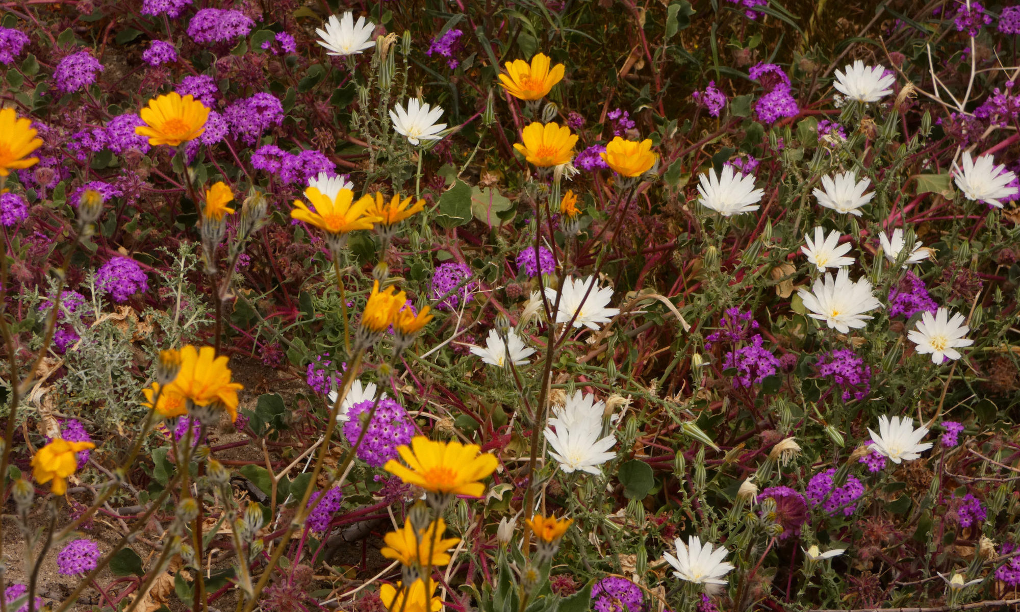
One way North meets South is through the commonalities of their wildflowers. Both Denali and Death Valley can have phenomenal flower seasons. And plants in both parks use similar adaptations to survive in their harsh environments.
Both parks host an incredible variety of wildflower species.
Both Denali and Death Valley pose extremely difficult challenges for the plants and animals that live there. Although one place is scorching hot and the other bitterly cold, they share an element that amplifies the effects of both extremes – wind.
They’re not all belly flowers!
In both places, the growing season is short but intense. In both, you’ll also find that a lot of flowers grow low to the ground. Belly flowers. They often grow closely in mounds or in mats covering the ground, working together to avoid the drying effects of the relentless wind.
Growing low to the ground in a mound can protect the flowers from wind and conserve water.
Many plants in both places are covered with fine hairs, which keep Denali’s flowers a little warmer and protect Death Valley’s from the harsh sun.
Denali or Death Valley?
The biggest draw for me personally is that both Denali and Death Valley are incredibly wild, something I’m aching for on tame, benevolent Orcas Island this winter. There is something about the harshness of those landscapes that speaks to my soul. And of course, they’re also both awe-inspiringly beautiful.
For this week’s Lens-Artists Photography Challenge, let’s get wild! I’m talking about Mother Nature untouched and untrammelled, allowed to get on with her work without human help or hindrance.
“Those who contemplate the beauty of the earth find reserves of strength that will endure as long as life lasts.”
Rachel Carson
Everyone can find some wild to get close to in their life, even if it’s only a flower.
Maybe you’re lucky and have access to some truly wild landscapes. Perhaps you’re not. But give her a chance, and Nature will break free and get wild wherever we let her! Even if your only access to the natural world is the local park, you will certainly find something wild in your world. It could be a bird migrating through on its way north and south, or a wildflower springing up on an empty lot.
I don’t want to see groomed gardens or animals in the zoo. No people or signs of people. I want to see and revel in the natural world in your posts. Where’s the wildest place you’ve ever been? Where do you go to let Mother Nature regenerate your spirit? Please share with us the wild places, plants and beings that are close to YOUR heart!
“But love of the wilderness is more than a hunger for what is always beyond reach; it is also an expression of loyalty to the earth which bore us and sustains us, the only home we shall ever know, the only paradise we ever need – if only we had eyes to see.”
Edward Abbey
Life in the Wrangells, gateway to the wilderness
The natural world is my passion in life, and I love to share it. A long time ago I decided the most important goal in my life was to wake in beauty every day. Because I’ve made that a priority, I’m more fortunate than most when it comes to being close to nature. With a telephoto lens, this is the view from my bedroom window.
The price for that view is no running water or indoor toilets, and the hard work and logistical challenges of attempting to maintain an off-the-grid homestead. But it’s a price I’m happy to pay, because every morning when I wake up, the angels sing!
I live in the center of Wrangell-St. Elias National Park & Preserve in Alaska, one of the biggest protected wildernesses on the planet. But these days I usually snowbird it and go south in the winter. There are too many beautiful places in the world to spend your life in just one, no matter how wonderful that one is.
I migrate, like the birds.
I used to be a ranger in Death Valley National Park, which has more wilderness than any other national park outside Alaska. Pretty easy to find the wild there.
A nameless canyon in Death Valley National Park
My favorite way to get next to the wild is to get up close and personal with wildflowers. Drop down to their level. Breathe in their fragrance. Get out a magnifying glass to really check out the intricacies of the tiny flowers. Revel in their beauty, but don’t pick them. Leave them living, so others will have a chance to appreciate them, too. I spend March and April most years following the wildflower bloom, first in the desert…
And then catching the spring flowers in the Sierras and Oregon on my way back to Alaska.
And then there’s the sea. Another way to get close to the wild in the world. I have really fallen in love with the seashore in the last few years. What could be wilder than the ocean?
The ocean is so wild it’s like another planet!
“Wilderness is not only a haven for native plants and animals but it is also a refuge from society. It’s a place to go to hear the wind and little else, see the stars and the galaxies, smell the pine trees, feel the cold water, touch the sky and the ground at the same time, listen to coyotes, eat the fresh snow, walk across the desert sands, and realize why it’s good to go outside of the city and the suburbs.”
John Muir
We need to learn to share!
Wild places are important because we need to learn to share our planet with everything else that calls it home. It does not belong to us exclusively, although we all too often act like it does.
Wild places are also important because they rejuvenate our souls. Wilderness is essential to our mental health. What a sad world it would be if we had no wilderness. Celebrate the wild in the world this summer, and please protect it wherever you may find it!
“…the word of the Lorax seems perfectly clear. UNLESS someone like you cares a whole awful lot, nothing is going to get better. It’s not.”
Dr. Seuss
Celebrate and care for the wild in your world!
Please join me in this Lens-Artists Photo Challenge and share the wild in your world. Remember to use the lens-artists tag and include a link to my original post.
Next week, Patti will be offering LAPC #151, so be sure to check out her site then! Her theme is From Large to Small. Pick a color and take several photos that feature that color. Start with a photo of a big subject in that color (for example, a wall) and move all the way down to a small subject in that same color (for example, an earring).
Thank you to Tina, Amy, Ann-Christine and Patti for inviting me to host this challenge. It’s wonderful to be part of the Lens-Artists community and I look forward to seeing all your wonderful wild posts this week.
Amy of The World is a Book chose “A River Runs Through It” as this week’s Lens-Artists Photo Challenge, so I thought I would showcase the Copper River and its tributaries, rivers running through the Wrangell Mountains. I live deep in the heart of Wrangell-St. Elias National Park. I’m surrounded by rivers. I cross 2 rivers just to get home when I reach the end of the McCarthy Road!
Not all of these rivers are called rivers. In Alaska, some rivers are only creeks, and many creeks are big enough that they should be considered rivers. McCarthy Creek is definitely one of these.
Kayakers on McCarthy Creek
McCarthy Creek runs into the Kennicott River, the river that separates McCarthy and Kennicott from the rest of the road system in Alaska.
The only way for visitors to visit Kennicott and McCarthy is to cross a footbridge over the Kennicott River.
If you drive the McCarthy Road, one of the rivers you cross is the Gilahina. The Gilahina is a bit unusual for this region because it is not a glacial stream but a clear stream, created by snowmelt instead of glacier melt. It is also one of those rivers that might more accurately be called a creek.
Old Railway Trestle from the Copper River Northwestern Railway over the Gilahina River
Most rivers in the Wrangells are glacial streams. Glacial streams carry heavy loads of debris and silt that block the flow of the water, constantly changing its course. River beds are very wide to accommodate these changes, creating a pattern called braided streams.
The Nizina is a good example of a braided glacial river.
Wonder why so many Alaskan rivers end in na? Na means river in Athabaskan! All these streams I’ve mentioned flow into the Chitina River. Chitina means “Copper River” in the language of the Ahtna people, an Athabaskan tribe. The Chitina River is THE major tributary of the Copper River. It carries much more water than the main branch of the river. This is because it drains the southern slope of the Wrangells and the northern slopes of the Chugach Mountains within the park. The northern slopes of the Wrangells, the watershed of the Copper above the confluence, are in the rainshadow and do not receive as much precipitation.
The Chitina River
The Chitina joins the Copper River at the town of Chitina. The Copper River is one of the world’s most important wild rivers, running nearly its entire length through a vast wilderness. It’s the tenth-largest river in North America. It carries one of the greatest silt loads of any river in the world.
All that silt has built the Copper River delta at the mouth of the river, the largest contiguous wetland on the entire Pacific Coast. This area is vitally important to birds. It’s an important stop on the Pacific Flyway, one of the continent’s main migration routes. The entire world population of western sandpipers and dunlins stop here on their northern migration. The delta also harbors the world’s largest population of Trumpeter Swans.
The Copper River is also home to the best salmon in the world, Copper River Reds.
The upper Copper River and Mt. Sanford
The rivers of the Wrangells are all frozen now, but breakup will be here before we know it. Cheers to the mighty Copper River and all its tributaries!
The refuge is an incredible winter destination for those of you who are fellow nature addicts. The Bosque is bird nerd heaven.
Lots of birds at Bosque del Apache
You’ve probably seen the pictures. Thousands of snow geese and sandhill cranes, that’s what the Bosque is famous for.
And for good reason. The cranes are everywhere – in the marshes, in the fields, flying overhead.
Cranes are everywhere
The snow geese are a little more elusive. My first day in I didn’t see any at all. But when you do find them, you find a lot! Thousands. The snow geese travel in huge flocks of hundreds, even thousands, of birds as they move from pond to pond.
When I was there, the geese were spending most of their time on the other side of the river, where they didn’t have to deal with tourists like me.
Snow Geese
The Entrance Pond
But there is one time and place where you are very likely to find them. No guarantees. (I did get completely skunked by the geese my first day.) There is a long, shallow. marshy pond located shortly after you cross into the refuge on Old Highway 1. Flocks of geese show up just before sunrise and take off soon after the light hits the water.
You’ll find the cranes, there, too. After all, the cranes are everywhere. The shallow pond is a great roost for them at night. It’s deep enough to keep the coyotes at bay but shallow enough to sleep in.
Crane taking off
It’s a tradition for the bird nerds who frequent the Bosque. It’s kind of like watching the sunset in Key West, a crowd gathering to applaud an everyday natural phenomenon.
Lines of photographers gather along the berm next to the pond, like combat fisherman in Alaska, tripod to tripod. Instead of salmon, they’re trying to catch that perfect shot, waiting for that sometime moment when all the geese take off at once. It doesn’t always happen, but when it does…
Bird Nerds
These are die-hard nature photographers. I was part of the maybe 3% who DIDN”T have a lense as long as your leg.
Most of these folks come from a different tax bracket than I do. I overheard a conversation -“Well, I didn’t get the upgrade to the balcony room for the Antarctica trip because they wanted another 25,000 and I thought that was a little steep.” Uh-huh. No wonder she has that big long lense and I don’t.
As a photographer, I found it a great place to practice, and learn the art of nature photography. Low light and lots of movement are difficult taskmasters, teaching new skills in the art of capturing the essential moment. Practice, practice. I could see my photos improve with every day I had to learn here.
Northern Pintail
Refuge Roads
If your lense isn’t long enough to get that National Geographic shot at the pond, head on up to the other refuge roads and trails. There are plenty of other birds to see here, too.
Nestled in farming country along the Rio Grande River, the Bosque provides a patchwork of different habitats. From grasslands to marshes to patches of woodland, it’s a peaceful, pastoral setting.
Immature Red-Tailed Hawk
Bosque del Apache is intensively managed to recreate conditions similar to what was found along the Rio Grande before the river was dammed and tamed. Fields are flooded to create temporary marshy areas, just as if the Rio Grande had flooded its banks with summer monsoons or fast-melting snow from the mountains. These ephemeral floods create an everchanging mosaic that supports nourishing plants like chufa and millet for the birds and other wildlife to eat.
Although there are two wonderful loops you can drive and half a dozen trails, most of the 57,331-acre refuge is not easily accessible to the general public. Thirty thousand acres of Bosque del Apache are managed as wilderness.
Roadrunner
Stressing out at work and need a little more peace in your life? Come here and slow down. It’s zen, a perfect spot for a bit of nature therapy. A dozen varieties of waterfowl feed in the ponds and flooded fields. Raptors perch on branches and songbirds flutter by or rustle through the grasses. There are always birds flying by. This land is so full of life!
It’s not all birds, either. You might see deer, javelina, even a bobcat. I watched a skunk trot down the road one afternoon.
Javelina
This land has a subtle beauty. It grows on you. It’s a place you could come day after day and never tire of. It’s a place that changes with every passing day, with every passing hour, yet still remains constant. It is a place to which I know I will return again and again.
Lodging
There is no camping in the refuge. There are a couple of spots where you can camp near San Antonio, the nearest town. However, it is very cold at night, with temps in the teens, during the prime time of year for the birds at Bosque del Apache. The camping areas are a muddy mess whenever it rains, too.
It’s a zen kind of place.
San Antonio has limited lodging. There are a couple of Bed & Breakfasts, an RV park or two and a couple of trailer/camper options available through Airbnb. There are two restaurants in this tiny town vying for the title of “best green chile cheeseburger in New Mexico”, though, so you may want to stop for lunch one day.
Most visitors stay in Socorro. It’s a charming town, big enough to support a good coffee shop and a micro-brewery but with a decidedly working-class feel to it. Socorro has not been gentrified, not quite yet. It means getting up a little earlier in the morning, though, as it is a 20-25 minute drive from Socorro to the pond.
It’s worth getting up early!
But it’s worth the drive. When the cackling of the geese rises from a murmur to a roar and you watch thousands of birds burst into flight instantaneously, you will experience that National Geographic moment. You, too, will hold a special place in your heart for Bosque del Apache.
The Peak-to-Peak Highway is one of my favorite Colorado scenic byways. My recent sojourn down this beautiful road was an incredible trip down memory lane, scenic but also big on nostalgia.
The Peak-to-Peak is the closest access to Colorado’s alpine for folks living in the northwest Denver/Boulder metro area. Since that’s where I grew up, this road was once my favorite way into the high country.
You can sometimes catch this kind of action going on in downtown Estes Park.
The route starts (or ends) in Estes Park, the gateway to Rocky Mountain National Park. I spent 2 summers there in my early twenties, the first mountain town I ever lived in.
In a landscape created by the rubble left behind by ancient glaciers, lumpy ridges and random boulders painted with lichens form the bones of the land. Stately Ponderosa pines and small groves of aspen adorn huge, park-like meadows, superb habitat for herds of elk. Tromping the trails whenever I had a chance, this country crept deep into my soul as I made the transformation from a city kid to a mountain woman.
Long’s Peak
Shortly after passing Lily Lake south of Estes, there’s a turnoff to reach the Long’s Peak trailhead. Long’s Peak is the northernmost fourteener (mountain over 14,000 ft.). in Colorado It was the first fourteener I ever climbed.
It’s a scramble, not a trail, to get to the top. The climb turned into an epic adventure when we were caught near the summit by a quick-moving thunderstorm. Torrents of hail felt like ball bearings under our feet as we charged down the slippery scree-covered slope. I watched a bolt of lightning break off a chunk of the mountain the size of a small house and send it crashing down on the slope below. Intense.
The Peak-to-Peak provides access to many other alpine adventures. Trails in the Wild Basin area near Allenspark travel along creeks filled with cascading waterfalls to pristine lakes. Climb higher, above the treeline, and immerse yourself in a tapestry of tiny tundra wildflowers.
Walk by waterfalls in Wild Basin
Indian Peaks Wilderness
The Indian Peaks Wilderness lies south of Rocky Mountain National Park, just a few miles west of the highway. I remember the challenges of my first week-long backpacking trip as I revisit Brainard Lake and gaze at the peaks and passes beyond.
When I hiked the Continental Divide one summer a few years later, the Indian Peaks Wilderness was one of my favorite sections. I recall how we spent the best day of the entire trip here, up near Fourth of July Mine and Mt. Neva.
Brainard Lake gateway to the Indian Peaks
The Towns
At the foot of the Indian Peaks, you’ll find a smattering of old mining camps, towns like Ward, Jamestown, and Eldora, ghost towns turned hippie havens. The friendliest and funkiest of them all is Nederland.
It’s definitely a hippie town. It’s the home of the Carousel of Happiness. Nederland was the third community to legalize pot in Colorado, just after Denver and Breckenridge. The locals call themselves Nedheads.
Carousel of Happiness
Nederland celebrates the eclectic and just plain weird. Case in point – the town hosts Frozen Dead Guys Days every March. This festival celebrates the attempt by a local resident to practice a little homemade crionics, stashing his grandfather in a storage shed with a bunch of dry ice, holding out for some future date when the miracles of science could bring him back to life. Some of the fun things to do in Nederland during the festival include coffin races, frozen t-shirt contests, and a polar plunge.
Just past Nederland is Rollinsville. This old railroad town once had a fun bar, the Stage Stop (now a restaurant under new owners). I loved dancing on the timeworn hardwood floor to name acts like Tab Benoit.
The Stage Stop used to host good bands.
Rollinsville also reminds me of my first backpacking disaster. I took my little sister and brother with me to teach them the joys of backpacking. Crossing a creek on an old log, I proceeded to teach them how to prevent hypothermia after the log snapped in two and dumped me in the creek. Then it started to snow. Eventually, the snow turned to rain and came down in torrents. It didn’t stop. In imminent danger of being stranded by flooding, we bailed and hiked out to Rollinsville to beg a ride home.
The Peak-to-Peak is one of the most popular roads in the state when the aspens turn gold. Signs on the highway warn leaf-lookers that they are not allowed to stop in the middle of the road when taking pictures of the fall colors.
Fall Colors
The scenic byway ends at the town of Black Hawk. There aren’t many memories left for me here, though. When I was growing up, Black Hawk and neighboring Central City were practically ghost towns, rich in history but with no economic base to support their residents. The towns sponsored a referendum to allow legalized gambling to create jobs and provide some tax revenue for the county. Now there is an economic base. It seems like a new casino opens up every other week here. The facades of a few of the buildings are all that remain of the old towns.
Black Hawk old & new
Although the Peak-to-Peak may not hold as many memories for you as it does me, it is still well worth the travel. Views of the Continental Divide, golden aspen groves, access to wilderness and a host of delightful communities are just a few of the treasures you will find along the way.
St. Malo Chapel on the Rock is a well-known landmark along the Peak-to-Peak.