For this week’s Lens-Artists Photography Challenge, Patti invites us to explore empty spaces in our photography. Empty spaces can draw more attention to our subject, as it does in this wildflower photo.
Empty spaces draw attention to your subject.
In wildlife photography, leaving a lot of empty space in front of your subject gives them room to move.
Empty space gives this meadowlark plenty of room to strut his stuff.
Or empty spaces can be used in landscape photography to evoke a mood or illustrate the vastness or wildness of a place. Possibly my favorite place to capture emptiness in landscape photography is Death Valley National Park.
There’s a lot of empty in Death Valley’s landscapes.
Empty spaces can accentuate the vastness of a landscape.
The empty space in this image highlights the vastness of the landscape
Including a lonely road can evoke a mood of solitude and remoteness.
A lonely road can evoke a feeling of solitude and adventure.
Since many of the most exciting nameless canyons in Death Valley are reached by hiking up an open wash, these wide open spaces create a sense of adventure and exploration in me.
A canyon in the Grapevine Mountains
But by far my favorite empty spaces to photograph in Death Valley are the sand dunes.
Mesquite Sand Dunes
With five major dune fields contained within the park, there are a lot to choose from.
Panamint Dunes
Emptiness can not only emphasize distance, it can also highlight the sheer massiveness of certain landforms.
Shock and awe – Empty landscapes can take your breath away.
Empty spaces don’t need to bring attention to a particular subject. They can also be used to bring attention to something more ephemeral, like color, as shown in the sunset colors of the feature image, captured in White Sands National Park. Empty spaces also make great palettes for abstract photography. Here is my favorite meditation image, a celebration of emptiness.
All is Illusion
Death Valley has been on my mind a lot lately. A huge storm in late August dropped over a year’s worth of precipitation in one day. When the park finally reopened 2 months later, the basin was still filled with water,
There’s water still in the Badwater Salt Flats.
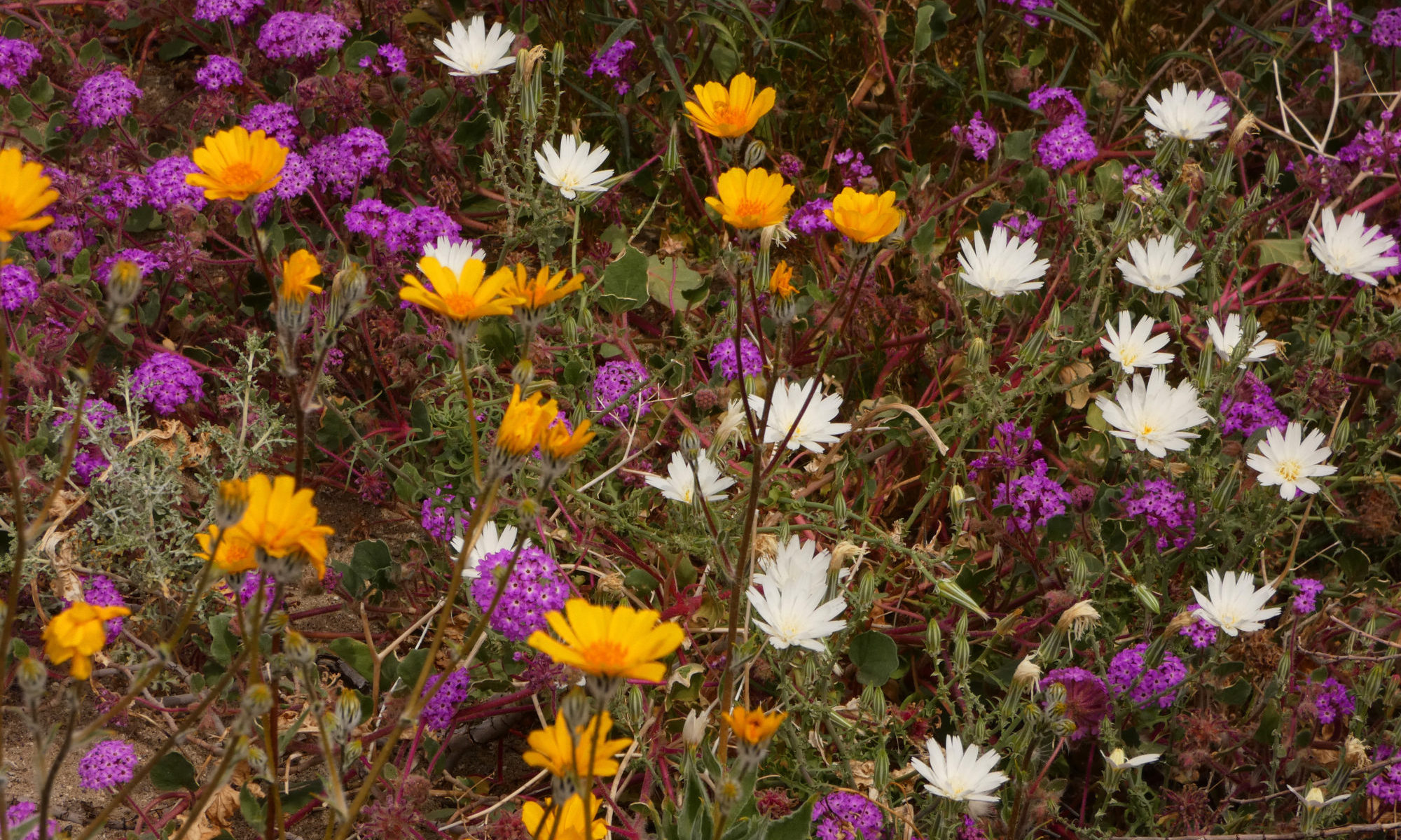
If there are enough little rain events in the upcoming weeks to keep seedlings moist, that big storm could lead to great things for 2024. It IS an El Nino year. Dare I hope? Could we actually have a superbloom? It’s possible. Stay tuned. I’ll be watching the weather closely. I’m keeping my dance card open, not committing to any housesits for 2024 yet. I’m hoping that instead, maybe this year, I can once again follow the flowers.
Can you imagine this wide open empty space filled with flowers? I can.
It’s a long way between towns in the desert, and sometimes the road seems endless and lonely. I love those far lonely drives, so I wouldn’t call it monotonous, but I do have to admit that there are big stretches where nothing especially stands out.
It seems that when there is a lack of natural landmarks, people feel compelled to fill in the blanks. Occasionally strange, off-the-wall objects spark up the view in those empty miles. I decided to write about a few of them for this week’s Lens-Artists Photo Challenge: Interesting Objects.
They’re listening. Is anybody out there?
Highway 60 in New Mexico is one of those highways. Towns are 20, 30, 40 miles apart. And when you do reach a town, don’t blink or you’ll miss it. But there are a few things out there that can shake you out of your highway trance.
One is the Very Large Array, a couple of miles east of Datil. It’s a radio telescope facility. Astronomers use radio waves to capture light in other spectrums and waves besides visible light, giving them a much more complete picture of what’s out there in the Universe than we could see if we just used visual information. The landscape is littered with humongous dish antennas, set out in a long, long line as far as you can see on either side of the highway.
Rural Outdoor Art
A little farther west I came upon this interesting collection of windmills. There were a couple of mannequins included in the display, I guess to give a sense of scale.
Catron County is popular with hunters. In the town of Quemado, I found a Christmas tree made out of deer antlers.
Merry Christmas?
When I drove through Arizona this year, it felt more like the Wild West than it ever had before. I’ve driven through the state many times, but never before have I seen so many signs and storefronts offering guns for sale. I live in Alaska, a state where most households own firearms, so I understand folks exercising their right to bear arms, but this year in Arizona it was over the top. It seemed a bit hysterical. I believe those folks are convinced Armageddon is coming. Or they want to help bring it on. In Wikieup, I guess maybe guns are not enough. They’ve got rockets!
Arizona likes its weapons.
One of the loneliest stretches of highway out there is California Highway 62, between Joshua Tree and the Arizona border. Suddenly, in the loneliest bleakest part of the road, you come to a few burnt-out foundations and crumbling walls surrounded by a broken-down barbwire fence. The fenceposts are decorated with sneakers, thousands of them. They’re mostly sneakers, but there are a few other shoes and gloves included in this bizarre display. Why did this site become the West’s athletic shoe graveyard? I have no idea.
Another rural art installation. This one is anonymous and interactive, kind of like graffitti.
These are only a few of the many strange and interesting objects to be found along those lonely desert highways. Maybe you have a favorite that I haven’t mentioned. Share it with us in the comments.
Thank you, Patti, for hosting this week’s photo challenge.
The very first time I saw Death Valley the first thought that popped into my head was “Boy, but this is a barren landscape!” But right on the heels of that thought came a second, this one attached to a sense of wonder – But Oh! The colors!
I called this viewpoint “Better than Zabriskie”. It was my personal meditation spot. Only a ten-minute walk from the road and less than half a mile from world-famous and hopelessly crowded Zabriskie Point, I found it while exploring a little wrinkle in the landscape and was the only one that knew it was there. A great place for solitude on a busy holiday weekend!
So this week I’d like to share a different kind of rock art with you, Mother Nature’s masterpieces. I’m going to get a little artsy-fartsy and share some abstract photography, portraits of those fantastic colors, patterns and texture that can be found in every corner of the national park.
A glimpse of the Last Chance Range
I’m convinced that every color of the rainbow can be found somewhere in Death Valley’s rocks. I’m so convinced that when I was a ranger there, I played a little game as an icebreaker, to slow my visitors down on my Nameless Canyon hikes and sharpen their powers of observation. I picked up a random assortment of paint sample chips at the hardware store. I included lots of variety – purples, blues, yellows, pinks, browns, tans, greys – no two colors exactly the same. It was a big box hardware store. I got LOTS of paint chips.
Pinks and greens and yellows…
Then I cut them all to a uniform size and put them in a bag. Each hiker had to blindly thrust their hand in the bag and pull out three paint chips, then find its EXACT match in the landscape we traveled through.
It’s not only the colors, it’s the patterns and textures that make Death Valley’s rocks so fascinating.
There was a lot of eye-rolling and exclamations of “I’ll never find THIS color!” I did end up removing 2 or 3 shades of blue and one particular red chip. True black was a surprisingly difficult color to find. But nearly every time, each hiker would eventually find all 3 of their colors, no matter what they picked out of the bag.
Orange is the predominant color at Ubehebe Crater. Although the crater was formed by volcanic action, this orange rock, surprisingly enough, is sedimentary.
Some areas are more colorful than others, world famous for their colors, it’s true. But even the hills that look a uniform baked brown from the road reveal their loveliness in the layers and shades you will find if you get a little closer.
The shimmery glow of “candle drippings” in the Kit Fox Hills. Candle drippings are mineral runoff on the canyon walls that sometimes builds up into elaborate patterns, Mother Nature’s tapestries.
When you delve deeper, all those colors, layers and patterns reveal a plethora of geologic events and eras. If only the rocks could talk, what stories they could tell!
Noonday Dolomite, the “marble” that makes Mosaic Canyon such a fun hike!
So it doesn’t matter if it hasn’t rained all year. It doesn’t matter if it’s a poor flower year, or the wrong season. You can visit this national park and still see a brilliant display of color, because Death Valley rocks!
Crazy swirly mountainside in the Funeral Mountains
Thank you, Ann-Christine, for bringing us this week’s Lens-Artist’s Photo Challenge, “You Pick It”. Also thanks to Tina for the art inspiration and Amy for the desert rocks inspiration.
Beautiful warped and twisted stone from Monarch Canyon in the Funeral Mountains
A rain event in Death Valley is a very unusual occurrence. After all, it IS the driest place in North America. With only about 2 inches of precipitation a year, rainstorms don’t happen very often. Rain events are even rarer.
I worked at Death Valley for 8 winter/spring seasons. In that time, I witnessed 2 rain events.
Standing at the mouth of Titus Canyon watching the first rainstorm of February 2010 come in over the Panamints
A rain event is much more than just a rainstorm. it has long-lasting repercussions. It can totally transform a landscape, and those transformations are part of the event. These are indeed special moments.
Badwater Salt Flats after the first storm
My first rain event was in 2010. During the winter of 2009/2010, it didn’t rain at all. All the oldtimers said it would be a poor flower year that spring. Too dry.
I spent a lot of time hiking the sand dunes that February because there were many times that the canyons were too dangerous. It rained and rained and rained.
Then February came, and with it, a series of Pineapple Express storms. A Pineapple Express is an atmospheric river formed above the ocean waters near Hawaii. Coming from the south, they dodge the high Sierras, leaving them with plenty of water to dump on Death Valley. We got 3 storms in a row. That February we received an inch and a half of rain. It was the rainiest February in Death Valley’s history.
The sand dunes were transformed into a desert oasis.
It was so wet that pools formed in the sand dunes, the only time I ever saw that happen. It looked like a true desert oasis.
Alpenglow on the Grapevine Mountains reflected in an ephemeral pool
The biggest change, though, was the Badwater Salt Flats. The salt flats were transformed into a lake, filled with about 7 inches of water for miles in every direction. There was so much water a friend went kayaking just for the photo op. With all the fresh snow on the Panamints, this symbol of the driest of deserts became almost alpine in appearance.
The lake at Badwater – deep enough to kayak.
The oldtimers still predicted a poor flower year, though. They said the rain came too late and there wouldn’t be time for the tender seedlings to get a good start before it became too hot.
They were wrong.
2010 turned out to be a good flower year after all.
My second rain event was the big one, a historic one, the great flood event of Sunday, October 17, 2015. It destroyed half the highways in the park. Scotty’s Castle is still closed due to this rainstorm.
It was literally my first day back to the park for the season. I needed to go to Pahrump, the nearest town, 60 miles away, to stock up since I was just moving in. It had been raining off and on for 2 days. My boss told me to be careful, there was flash flooding down by Death Valley Junction.
Badwater in early December 2015
I made it through the water at that low spot alright, but that afternoon the storms came back in with a vengeance. I could hear the radio reports as I shopped, the calamitous beeping that heralded a severe weather alert. When I walked outside, I could see the blackest sky ever out towards the Northwest, contrasting sharply with the brilliant flashes of dozens of lightning strikes.
I tried to hurry home. Things were starting to look serious. I knew I had to hustle to make it before the road was closed at Death Valley Junction. It had started raining, hard, and the thunder and lightning to the Northwest was truly something to behold. A light show, Fourth of July fireworks! I’ve never seen so many lightning strikes. I thought to myself that I was glad I wasn’t at Scotty’s Castle. Things looked really bad in that direction.
Storm over Death Valley Buttes
But they were bad enough where I was. Would I make it in time? The road started to get sketchy. I could see the edges crumbling and I knew for safety’s sake I had to try a different route. They closed that highway less than 10 minutes after I turned around. More than the edges had crumbled.
I thought I’d go the long way around, up north towards Beatty. I was stopped by the sheriff. That road was out, too. I ended up spending the night with a friend, a woman I worked with who lived in Pahrump.
Badwater Road and Telescope Peak January 2016
We headed out in caravan to reach the park early the next morning, in radio contact with the park maintenance crew. There was one route that just might work. There was lots of water running on the road as we crossed washes. One crossing was doubtful. I could feel my little truck slow down and threaten to stall out. I was really glad we were caravaning. In hindsight, I wouldn’t cross water like that again. Within half an hour of when we went through, that road closed, too. But we made it.
The October monthly precipitation average for Death Valley is .07 inches. Death Valley received 1.3 inches of rain in October 2015, nearly all of it from the October 17 storm. That storm caused a lot of destruction to man-made structures and roads. But it also made some amazing changes to the landscape.
Imagine the ground growing thick like this with flowers – everywhere – for miles upon miles
Of course, Badwater Basin once again filled with water. No kayaking this time, though. By the time the road crew had cleared and repaired the road as far as Badwater the water levels were already down too far for that. Mud and debris flows trashed the Badwater Road. The southern part of the road was completely destroyed, the pavement twisted and shredded.
The change that impressed me the most, though, was at Artist’s Drive. A debris flow had completely inundated the main canyon, filling it brim to brim and splashing ten to twelve feet up the walls in places. This layer of mud is now a permanent part of Death Valley’s geological record, a layer of rock that will still show up thousands of years from now. I love to see geology happen!
The main wash in Artist’s Drive filled brim to brim, overflowing with mud from the debris flow.
And then, starting as early as the end of December, the flowers came out. And continued to come out, month after month, all the way to May. They were so thick on the ground you couldn’t take a step without trampling a flower. And they were all supersized, too.
For instance, Desert Five-Spot is usually a shy flower; the plant grows about 6 inches high, with only a few blossoms on each plant. In dry years, it will dwarf into a tiny belly flower only an inch or two high with one blossom. But during the 2016 Death Valley superbloom, I found a veritable plantation of five-spot bushes, all about 3 feet high with dozens of blossoms. One plant had 53 flowers! What a difference a little rain makes!
Desert 5-spot
Although the Artist’s Drive debris flow was the most thrilling change for me intellectually, the wildflower bloom is what struck my heart. It was the ultimate of all the special moments I’ve experienced in my Death Valley rain events.
For this week’s Lens-Artists Photo Challenge, Patti @ Pilotfishblog asks, “What images can you find that feature a subject that begins with the letter S? For an added challenge, capture an image that illustrates a concept with the letter S, such as serene, sharp, spooky, or silent.” So, see if I have succeeded!
Shocking Pink Shooting StarsSnowy slopes seem like superb skiing but are susceptible to slides. Stay safe!Surreal sealSurly snarling sealSweet Stone Sheep on a steep slopeSnake! Scary slithery Sidewinder sleeping in the shadeSlender Sandhill Cranes and a swarm of Snow Geese salute the sunrise.
When I think stripes, zebra is the first thing to come to mind.
Stripes are easy, I thought. There are lots of stripes in nature. I thought of the multi-layered sedimentary rock that makes up so many of the spectacular landscapes of the desert Southwest.
Grand Staircase Escalante National Monument
There are lines of light and shadow.
Death Valley Dunes
You see stripes everywhere.
Checks, not so much.
These are sort of checks – I guess.
After all, Mother Nature is not really into squares and rectangles much. That’s more of a human thing, in most cases.
This plant is sort of checked.
But there are exceptions. The guinea fowl is the exception in this case. They totally sport the checked look in their wardrobe.