An Unusual Occurrence – Death Valley Rain Events

Badwater Salt Flats

A rain event in Death Valley is a very unusual occurrence. After all, it IS the driest place in North America. With only about 2 inches of precipitation a year, rainstorms don’t happen very often. Rain events are even rarer.

I worked at Death Valley for 8 winter/spring seasons. In that time, I witnessed 2 rain events.

  • Death Valley National Park
    Standing at the mouth of Titus Canyon watching the first rainstorm of February 2010 come in over the Panamints

A rain event is much more than just a rainstorm. it has long-lasting repercussions. It can totally transform a landscape, and those transformations are part of the event. These are indeed special moments.

Death Valley National Park
Badwater Salt Flats after the first storm

My first rain event was in 2010. During the winter of 2009/2010, it didn’t rain at all. All the oldtimers said it would be a poor flower year that spring. Too dry.

Mesquite Flat Sand Dunes
I spent a lot of time hiking the sand dunes that February because there were many times that the canyons were too dangerous. It rained and rained and rained.

Then February came, and with it, a series of Pineapple Express storms. A Pineapple Express is an atmospheric river formed above the ocean waters near Hawaii. Coming from the south, they dodge the high Sierras, leaving them with plenty of water to dump on Death Valley. We got 3 storms in a row. That February we received an inch and a half of rain. It was the rainiest February in Death Valley’s history.

Mesquite Flat Sand Dunes & Grapevine Mountains
The sand dunes were transformed into a desert oasis.

It was so wet that pools formed in the sand dunes, the only time I ever saw that happen. It looked like a true desert oasis.

Grapevine Mountains
Alpenglow on the Grapevine Mountains reflected in an ephemeral pool

The biggest change, though, was the Badwater Salt Flats.  The salt flats were transformed into a lake, filled with about 7 inches of water for miles in every direction. There was so much water a friend went kayaking just for the photo op. With all the fresh snow on the Panamints, this symbol of the driest of deserts became almost alpine in appearance.

Badwater Salt Flats
The lake at Badwater – deep enough to kayak.

The oldtimers still predicted a poor flower year, though. They said the rain came too late and there wouldn’t be time for the tender seedlings to get a good start before it became too hot.

They were wrong.

Notchleaf Phacelia
2010 turned out to be a good flower year after all.

My second rain event was the big one, a historic one, the great flood event of Sunday, October 17, 2015. It destroyed half the highways in the park. Scotty’s Castle is still closed due to this rainstorm.

It was literally my first day back to the park for the season. I needed to go to Pahrump, the nearest town, 60 miles away, to stock up since I was just moving in. It had been raining off and on for 2 days. My boss told me to be careful, there was flash flooding down by Death Valley Junction.

Badwater Salt Flats
Badwater in early December 2015

I made it through the water at that low spot alright, but that afternoon the storms came back in with a vengeance. I could hear the radio reports as I shopped, the calamitous beeping that heralded a severe weather alert. When I walked outside, I could see the blackest sky ever out towards the Northwest, contrasting sharply with the brilliant flashes of dozens of lightning strikes.

I tried to hurry home.  Things were starting to look serious. I knew I had to hustle to make it before the road was closed at Death Valley Junction. It had started raining, hard, and the thunder and lightning to the Northwest was truly something to behold. A light show, Fourth of July fireworks! I’ve never seen so many lightning strikes. I thought to myself that I was glad I wasn’t at Scotty’s Castle. Things looked really bad in that direction.

Death Valley Buttes
Storm over Death Valley Buttes

But they were bad enough where I was. Would I make it in time? The road started to get sketchy. I could see the edges crumbling and I knew for safety’s sake I had to try a different route. They closed that highway less than 10 minutes after I turned around. More than the edges had crumbled.

I thought I’d go the long way around, up north towards Beatty. I was stopped by the sheriff. That road was out, too. I ended up spending the night with a friend, a woman I worked with who lived in Pahrump.

Badwater Road
Badwater Road and Telescope Peak January 2016

We headed out in caravan to reach the park early the next morning, in radio contact with the park maintenance crew. There was one route that just might work. There was lots of water running on the road as we crossed washes. One crossing was doubtful. I could feel my little truck slow down and threaten to stall out. I was really glad we were caravaning. In hindsight, I wouldn’t cross water like that again. Within half an hour of when we went through, that road closed, too. But we made it.

The October monthly precipitation average for Death Valley is .07 inches. Death Valley received 1.3 inches of rain in October 2015, nearly all of it from the October 17 storm. That storm caused a lot of destruction to man-made structures and roads. But it also made some amazing changes to the landscape.

Greenwater Road
Imagine the ground growing thick like this with flowers – everywhere – for miles upon miles

Of course, Badwater Basin once again filled with water. No kayaking this time, though.  By the time the road crew had cleared and repaired the road as far as Badwater the water levels were already down too far for that. Mud and debris flows trashed the Badwater Road. The southern part of the road was completely destroyed, the pavement twisted and shredded.

The change that impressed me the most, though, was at Artist’s Drive. A debris flow had completely inundated the main canyon, filling it brim to brim and splashing ten to twelve feet up the walls in places. This layer of mud is now a permanent part of Death Valley’s geological record, a layer of rock that will still show up thousands of years from now. I love to see geology happen!

Artist's Drive
The main wash in Artist’s Drive filled brim to brim, overflowing with mud from the debris flow.

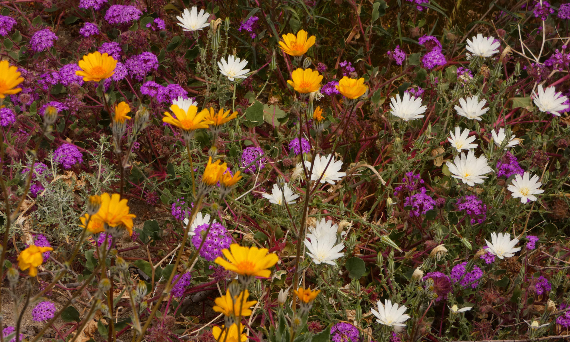
And then, starting as early as the end of December, the flowers came out. And continued to come out, month after month, all the way to May. They were so thick on the ground you couldn’t take a step without trampling a flower. And they were all supersized, too.

For instance, Desert Five-Spot is usually a shy flower; the plant grows about 6 inches high, with only a few blossoms on each plant. In dry years, it will dwarf into a tiny belly flower only an inch or two high with one blossom. But during the 2016 Death Valley superbloom, I found a veritable plantation of five-spot bushes, all about 3 feet high with dozens of blossoms. One plant had 53 flowers! What a difference a little rain makes!

Death Valley Superbloom 2016
Desert 5-spot

Although the Artist’s Drive debris flow was the most thrilling change for me intellectually, the wildflower bloom is what struck my heart. It was the ultimate of all the special moments I’ve experienced in my Death Valley rain events.

Thank you, Tina of Travels and Trifles, for this week’s Lens-Artists Photo Challenge, Special Moments.

Death Valley Superbloom 2016
Alpenglow on the Black Mountains behind a field of Desert Gold


Biodiversity is an Emotional Issue

IPiedrasPiedras Blancas Wildlife Refuge

When it comes to biodiversity, my feelings run through the full gamut of emotions.

Happiness

Bosque del Apache National Wildlife Refuge
Biodiverse landscapes make us happy.

Being close to nature has been a priority of mine for nearly my whole adult life. From my first backpacking trip on, I realized that immersing myself in landscapes teeming with life – many different forms of life interacting easily and naturally with each other – kept me healthy, happy and sane.  Knowing that I am just a piece of a very big puzzle, a cog in the unbelievably complex wheel of the Universe,  helps me to regain a proper perspective when I get overwhelmed by challenges that seem too great for me to handle. It’s really not all about me; my problems are so inconsequential when I am surrounded by the real Big Picture.

I’m not alone. It has been acknowledged by cultures all over the globe that healthy, thriving ecosystems are necessary for our physical, mental, and spiritual health.  Variety IS the spice of life.

Gratitude

Death Valley Monkeyflower
Plant biodiversity is incredibly important in our lives.

Every day I am grateful for the complexity of life. Biodiversity is responsible for all the choices we have in the foods we can eat. It is responsible for life-saving medicines, with more being discovered all the time.  Lack of biodiversity has been connected to many disease outbreaks. Biodiversity is accountable for resiliency and flexibility in the face of dramatic changes to our planet.  It is necessary for the very air we breathe and water we drink.

As a park ranger, biodiversity is essential to my employment. It’s probably the main reason people visit national parks. But you don’t have to work in the tourism industry to be economically dependent on biodiversity. According to the Living Planet Index, people derive approximately $125 trillion of value from natural ecosystems each year.  Gotta be grateful for that.

Concern

Bosque del Apache National Wildlife Refuge
The sharp decline in bird populations worldwide is a matter of great concern.

We are losing our biodiversity at an astonishing rate, a reason for great concern. Species extinctions currently vary between 100 and 10,000 times the background extinction rate of one to five extinctions a year over the history of the planet. That doesn’t even get into the decline in populations of many species not yet in danger of extinction.  The average population size of vertebrate species has declined by 68 percent from 1970-2016. Since biodiversity is essential to our survival, we should all be concerned.

Sadness

Monarch Butterflies
The Western Monarch Butterfly population is down more than 99% from the 1980s count.

Witnessing this decline breaks my heart. It makes me very sad when I read about mass die-offs of seabirds in western Alaska or see with my very own eyes the decline of a species like the Monarch Butterfly.

Fear

Denali National Park
After a lengthy court battle, grizzly bears are still covered by the Endangered Species Act in the contiguous US.

As I watch ecosystems crash one by one, as we continue to do little to nothing to address this issue, I feel fear. I fear for our quality of life and our very survival as a species as we continue to degrade the resources we need to depend on, both now and in the future.

Guilt

Wramgell St. Elias national Park & Preserve
Like most of us, I need to make more conscious choices.

I’m an American. I’m guilty. It’s ridiculous how much we Americans contribute to the loss of habitat and the loss of biodiversity. All because we have been trained to constantly want more, more, more, just to keep our consumer-driven culture intact.

I didn’t get a driver’s license until I was 50. I didn’t want to become part of the problem. But I am part of the problem. I’ve driven a couple of hundred thousand miles since then.

I’m not much of a consumer for an American. I’m not one of those getting Amazon packages every day. I seldom buy something unless I need it. But I don’t always buy organic or make wise choices about eating locally. Pesticides, herbicides, and industrial farming methods are some of the main drivers behind the loss of biodiversity. Transportation of foodstuffs from one part of the world to destinations tens of thousands of miles away is an incredible waste of our planet’s resources. I could do better. We all could do better.

Anger

graffiti on redwood tree
Disrespect for living things makes me angry.

Although I feel guilt, I feel a lot more anger. I feel angry at everyone that disrespects nature and the diversity of life. The thoughtlessness of an individual vandalizing or destroying a tree or a flower can make me mad, but the heartlessness of powerful corporations and individuals who put short-term profit before the long-term health of the planet makes me rage.

Despair

Sea Star and hermit crabs
Hermit Crabs scavenging a dead sea star

I’ve felt a lot of despair over the last 4 years as I’ve watched all the hard-won environmental reforms of the previous 50 years go by the wayside. I’ve felt despair as I’ve had to stand by while the Trump administration gutted the Endangered Species Act and the Migratory Bird Treaty Act, two key pieces of legislation for the protection of biodiversity.

It can be overwhelming when the reality of the situation really sinks in.  When I walk a beach in Olympic National Park that no longer supports starfish, or think of the reefs in the Florida Keys that I used to snorkel that are now white, dead skeletons, I feel despair.

Joy

Sea Otter
Who doesn’t feel joy when they see a sea otter?

But it’s not all doom and gloom. We humans have some amazing capabilities. We can turn things around when we really try. There are success stories out there. There are species that have been brought back from the edge of extinction and are now thriving.

Elephant seals are one of those species. So are sea otters. So are bison. They’re out there, those examples of times when we’ve corrected the mistakes we’ve made. I feel great joy when I see these success stories.

Hope

Yellowstone National Park
American Bison have come back from the brink of extinction.

“With unity, we can do great things.” – Joseph R. Biden

Although my emotions run the whole gamut, the main emotion I am feeling right now when it comes to biodiversity is hope. A new day is dawning. We have an opportunity right now to turn things around and build a better world for the future, a world where biodiversity matters. But to make this happen, we need to change our mindsets. Instead of asking ourselves, “What will best benefit me?”, we need to ask ourselves, “What will best benefit us, all of us? What policies can we enact that will be good for not just the short-term, but for the long-term health of our Mother the Earth?” We need to take a good look at how we do things and figure out better ways to do them, ways that protect biodiversity and lead to a cleaner, greener planet. We have a chance, and we need to act on it. Now.

“It’s time for boldness because there’s so much to do.” – Joseph R. Biden

Thank you to Patti of Pilotfishblog for this week’s Lens-Artists Photo Challenge theme, Emotions.

Wrangell-St. Elias National Park & Preserve
Biodiversity is good for all of us!

Answers to last week’s quiz – 1) Purple Cress, alpine 2) Purple Mat, desert 3) Bristly Langlosia, desert 4) Spring Beauty, alpine 5) Bigelow Mimulus, desert


Sea Arches of Mendocino County

Navarro Beach

My niece Jessica put up a post challenging her friends to flood FB with beach pictures. So I thought I’d bring on a little arch madness with a post on the sea arches of Mendocino County.

Mendocino Headlands
One of the arches you can see from the Mendocino Headlands

Sea arches are one of the most ephemeral of landforms, rarely lasting more than a century, often standing for only a few decades before the constant battering of the relentless surf sends them crashing down.

Point Arena-Stornetta Public Lands
Stornetta Highlands, California Coastal National Monument

For instance, Natural Bridges State Park in Santa Cruz had 3 bridges in 1904. Today only one remains. If you’d like to see how dramatic these changes can be in such an incredibly short time, check out this article that Gary Griggs wrote for the Santa Aguila Foundation. The before and after pictures are astounding!

Mendocino County Sea Arches
View from a tunnel on Seaside Beach

These geologic sculptures can be much more fragile than they look. Even thick, seemingly stable arches are subject to catastrophic collapse.  In March 2015 an arch collapsed at Point Reyes National Seashore, killing a woman. If you’re walking the headlands of northern California and see signs warning you to stay back from the edges of the cliffs, heed them. Erosion is on a fast track here.

Seaside Beach
They call the formation on the left The Whale. No idea why.

Geohazards like these catastrophic collapses will become more and more common in future years, due to sea level rise caused by climate change.

Sea Arches of Mendocino County
An arch north of Westport

Your children may not see the same arches you did when they visit the Pacific Coast. But the forces that destroy these landforms are constantly carving new ones, exquisite jewels in a dynamic landscape ruled by the sea.

Seaside Beach
A new arch forming – What will it look like ten years from now?

Driving Down Narrow Roads

Denali National Park

I thought I was used to driving on narrow roads. After all, I live at the end of the infamous McCarthy Road in Alaska.

The McCarthy Road

The  McCarthy Road has a reputation. It used to be considered the worst road in Alaska. Barely over one lane wide, the road had features like Hug-A-Boulder Bend, a dangerous blind corner.

The Kuskulana Bridge, a remnant of the old Copper River & Northwestern Railway, was another challenge. When it was built in 1910 the Kuskulana Bridge was the 17th-highest bridge in the United States.

Wrangell-St. Elias National Park
Kuskulana Bridge

Thirty years ago, the Kuskulana crossing was just a couple of planks wide with no guard rails. Imagine crossing then, with the river over 200 feet below and nothing to stop you if you misjudged the width of that plank! People used spotters to make sure their wheels stayed on the boards while crossing this perilous chasm. Most people turned back.

We still had Hug-A-Boulder Bend when I moved to McCarthy, but the Kuskulana had been upgraded to a full one lane. With guard rails! The road still had a reputation, though, for potholes, mudslides, and railroad spikes turning up in people’s tires. It would still take a good 3 to 4 hours to travel its sixty miles. In the summertime. On a good day.

Times have changed. Hug-A-Boulder Bend is no more, blasted away, no longer a safety hazard. The road is wider, mostly 2 lanes now. Part of it was chip sealed, which actually made it worse when the frost heaves hit after the first year of smooth sailing. Although flats are still common, nobody finds spikes in their tires anymore. The road is graded more often, although it still can get a bit rough due to potholes, mudslides, and beaver dams. These days it only gets really bad in the winter. But it would still be considered narrow by most folks.

the narrow dirt McCarthy Road
The McCarthy Road is still potholed and narrow.
The Denali Park Road

Another narrow road I know well is the Park Road in Denali National Park. I drove this road frequently when I worked as a ranger there for a couple of summers. Sections of the road are so narrow and hazardous that a driver needs to pull over at the wide spots to scout the upcoming curves and wait for approaching traffic. You have to go through a training session before you are allowed to drive on this narrow road.

That road is even narrower now.  It is literally sliding right off the cliff because of melting permafrost. Last summer heavy rains exacerbated the problem.  Mudslides stranded about 300 visitors for a couple of days until road crews could clear the debris. This summer the narrow road may not be open at all past Mile 41 as park and highway personnel search for a longer-term solution for the worst section.

the narrow Denali National Park Road
The Denali Park road may be closed this summer due to geohazards caused by permafrost melting.

I thought I was used to driving on narrow roads. But this winter’s travels have put a new spin on narrow for me.

Northern California Coast Roads

This month I’m housesitting on a narrow, winding road in Mendocino County, California. I have to slow down to 20 mph for the last half mile, then completely stop and throw the truck into first gear to negotiate the steep hairpin turn into the driveway. The road is so narrow that turning out of the driveway takes both lanes and I still nearly hit the massive redwood on the other side of the road every time I leave the house. The convoluted terrain along the northern California Coast means most of the roads around here are like that, extremely narrow and squiggly.

Like Denali, geohazards such as mudslides and roads falling off cliffs complicate matters here. Some of the ways climate change impacts these roads include rising sea level and increased severity of storms.

Narrow roads in Mendocino County
Take a sharp left switchback at the mailboxes.

These narrow roads all feel like four-lane highways, though, when compared to the Bursum Road. This New Mexico road leads to the tiny mining town of Mogollon.

The Road to Mogollon

This is Gila River country. the mountains where Geronimo and his band lived.  I can understand why he was the last chief to surrender. It’s incredibly wild terrain; challenging, rough and remote.  The first time I traveled in these mountains I learned to respect just how rough and remote they could be. This year’s travels made me respect them all the more.

Mogollon is kind of a ghost town. A couple of the old buildings have been refurbished into summer businesses, and a few residents live there year-round, but walking through on a winter’s day, you probably won’t see another soul.

Which is a good thing. I certainly wouldn’t want to run into anyone coming the other way on most of the Bursum Road. It’s a one-lane road hung on the edge of a cliff, and it’s relentless. It’s a long way in between spots wide enough to pull over enough to let another car pass in the opposite direction and it’s one blind curve after another for miles and miles. It was the scariest road I’ve ever driven.

Narrow road in Mogollon, NM
The road to Mogollon is dangerous and scary!

I couldn’t find a spot wide enough to turn around safely. I was praying, “Please let me survive this. Please, don’t let there be anyone coming the other way. I promise I’ll never come here again. This trip is not worth my life.” Just to make it even more challenging, the late afternoon sun was in my eyes on the way out. The prayers changed to “Lord, please don’t let me drive over a cliff.”

I was lucky. No one was coming the other way until  I crossed the cattle guard and hit a wider pavement and safety.  Right then I passed a big pickup pulling a trailer full of mining equipment headed to Mogollon. If I had left less than 5 minutes later I would have run into him at the most hazardous curve on the road. Perfect timing! Whew!  The Universe heard my prayers! The Bursum Road was the scariest road I had ever driven.

I didn’t take any pictures to show you just how scary it is. There was nowhere that felt safe enough to stop. But here’s a link if you want to travel this road virtually. It’s the only paved road I’ve ever traveled that I wouldn’t drive again because I feel the risk is too great. This is one scary road.

A Little Advice

Some advice for folks traveling narrow roads, wherever they may find them. SLOW DOWN around the curves!! PLEASE slow down. Someone might be coming the other way and on most of these roads, you’re a long way from help. Just sayin’.

Thanks, Amy, for this week’s Lens-Artists Photo Challenge, “Narrow”.

Wrangell-St. Elias National Park
Drive slow around the curves. Remember how remote you are.

The Future Is Happening Now!

Pacific Coast

For this week’s Lens-Artists Photo Challenge, Ann-Christine asks us to envision the future. It could be near future or far, personal future or universal.

“The future’s uncertain, but the end is always near. ” Jim Morrison

I read Tina’s post, with its warnings about the consequences of climate change. Climate change was already on my mind. I had just spent the morning at an open house held by the Navarro-By-The-Sea Center. They are trying to save the remaining historical buildings still standing at the site of the former town of Navarro-By-The-Sea, but the open house was held more to bring awareness of king tides and the rise of sea level due to climate change.

A king tide was in progress, so to get to the Center those of us without 4-wheel drive had to take a shuttle with high enough clearance to ford the water. The beach parking lot was completely underwater. Sea level is 6 inches higher than it was in 1950. This may not seem like much, but the rate is increasing dramatically, over 66% in the last 5 years. Now it’s rising at the rate of an inch every 5 years, and that rate is still going up. A lot of places are going under, and the king tides are a preview of what will become an everyday occurrence in the near future.

climate change
King tides and rising sea level

As I witness ecosystem crashes and see the current administration win one battle after another in its War Against Nature, I despair. When I contemplate the future, I fear we’re already past the tipping point.

I couldn’t go there. I thought of other signs of the consequences of climate change I could write about, but it all made me so sad. I couldn’t write a whole post with no hope, and I was feeling hopeless.

Navarro River Beach
Sea level is rising.

I needed some positivity, so I started playing Michael Franti as I read the post from Soybend, “Someday in the Future”. It was uplifting, positive and poetic, just what I needed. I then learned about new research connecting melting ice in the Arctic to the increasing prevalence of El Nino cycles.

I saw a teeny, tiny silver lining to the dark storm clouds of the future. More El Ninos = more desert wildflowers. Ironic that as so many other places dry up and desiccate, the California desert will get wetter.

Apricot Globemallow
More desert wildflowers?

I started thinking about desert wildflowers, and that led me to my personal near future, which is actually pretty exciting.

“The future’s so bright, I’ve gotta wear shades.”

Patrick Lee Mac Donald

I’m currently housesitting on the beautiful Mendocino Coast in northern California. Think redwoods and wild, secluded beaches with an abundance of arches and sea stacks.

Navarro Redwoods State Park
Love those Redwoods!

I’ll leave here in early March and go down to see the desert flowers. I’ll head east and travel through the Sierra foothills so I can avoid the urban insanity of San Francisco traffic. Along the way, maybe I’ll stop at Yosemite.

Yosemite National Park
Yosemite Falls

I have four flower destinations in mind. Death Valley received nearly an inch of rain over the winter, which is a decent amount for that place. When I passed through in mid-January, there were a lot of little seedlings coming up. I even saw a Turtleback blooming already. If the winds and heat aren’t too brutal, it might be a nice bloom this year. Since the last 3 years were abysmal there, I’m looking forward to and hoping for a good season this time around.

Death Valley National Park
Notchleaf Phacelia

Joshua Tree has gotten a lot of moisture this winter, both snow and rain. There’s a current winter storm warning there, so the precip is still happening. I think Joshua Tree might be THE place to check out this year, although I doubt if it will be quite as outrageous as it was last spring.

Joshua Tree National park
Purple Mat

Anza Borrego has gotten a fair amount of precipitation, too, over an inch in one winter storm. Smaller storms since then have kept the ground moist. Word is flowers are already blooming in Coyote Canyon.

Anza Borrego State Park
Wild Apricot

Last year I discovered Carrizo Plains. The rough dirt roads are hard on my little truck, but I’ll just have to try to go slow and pray the washboard isn’t TOO bad. I thought it had some of the best wildflowers I’d ever seen, and Carrizo got hit by all the same storms that have inundated Joshua Tree.

Carrizo Plains National Monument
Camping at Carrizo Plains

As I head back north to Alaska, those Sierra foothills and southern Oregon should be blooming. I’m not sure if I’ll travel back by the coast or interior yet, but by May I’ll be back home enjoying the incredible view from my front porch.

Mt. Regal
part of the view from my front porch

Happy flower hunting!


Witnessing the Demise of a Species

Ellwood Butterfly Preserve, Goleta, CA

Twelve years ago I visited the butterfly sanctuary in Pismo Beach, California. I’d never seen anything like it. Every tree in the grove was literally dripping with butterflies, streaming down in long garlands, camouflaged as dead leaves. It took a moment to see them, then. Aha! Wow! There are a kajillion butterflies here!

I went back to Pismo Beach yesterday. I saw maybe a dozen butterflies flitting around. No long streaming garlands. Hardly any butterflies at all.

Pismo Beach Butterfly Sanctuary
How I wish I could mend these broken wings!

I walked out the gateway from the grove, and then I saw a few butterflies. I watched one float down to the highway, fluttering in the breeze like a leaf in autumn. There were a couple of others in the road, three all together.

A car drove by, the wind from its wake bashing and battering the unfortunate creatures. One Monarch valiantly struggled to crawl out of the gutter, its tattered wings damaged beyond all repair.

With tears in my eyes, I coaxed it onto my finger, and carried it over to the nearby bushes. At least let the poor thing die peacefully, on a bed of leaves instead of in the cold, hard, red-painted gutter.

It’s hard to witness the extinction of a species.

Sweet Spring Nature Reserve Los Osos, CA
Eucalyptus flowers and fruit

The Western Monarch Butterfly population is down more than 99% from the 1980s count. This year, in the entire state of California, there are only 28,000. The Xerces Society (the bug people) estimate 30,000 as the tipping point for extinction. Numbers have dropped from 4.5 MILLION in the 1980s to 28,429 as of January 2019.

I first became aware of the Monarch tragedy around Christmas, when I was housesitting in Goleta, CA. Although I was lucky enough to see a few clumps of butterflies hanging from the trees, I learned that their numbers were down dramatically.

Pismo Beach Butterfly Sanctuary
Only one butterfly, where recently there were thousands

It really hit home for me when I was in Monterey in January and visited the sanctuary in Pacific Grove. I had visited that site, also, a dozen years ago on my journey up the California Coast. I must admit I almost took it for granted, there were so many butterflies roosting in the trees then.

I visited this year, and could count them on my fingers.

I admit I’m probably not the best at finding those clumps of butterflies, hanging like ripe fruit from the high branches of tall trees. They camouflage pretty well. Binoculars are helpful. Docents and naturalists who have been studying the insects are much better than I am at spotting them. But when I was in Pacific Grove, one of these experts had a spotting scope out, teaching a group of schoolchildren. He couldn’t find them, either. The ones I did see were flying too high for me to photograph any of them.

Pacific Grove has made a business out of the butterflies, advertising their town as “Butterfly Town USA” on big signs as you enter the village. Gonna have to rethink that ad campaign.

Monarch Butterfly

Walking the beaches of Pacific Grove I found a smooth, polished piece of bone, a vertebra from a fish. Its shape was an exact replica of a butterfly’s form, an apt souvenir from a lovely town where I sadly had the misfortune to witness ecosystems crashing on both land and sea. Death and beauty inextricably entwined.

Finding the last butterflies became a sort of pilgrimage for me. I spent a day searching out the sanctuaries near San Luis Obispo. First I went to Morro Bay State Park. A population lives in the eucalyptus next to the golf course. I spoke with an employee at the park museum. He recounted one time when he was golfing and saw clouds of thousands of butterflies overhead, migrating to these trees, one of those magic moments you remember for a lifetime. No more. I walked the trails and could not spot even one.

Sweet Spring Nature Reserve, Los Osos, CA
Sweet Spring Nature Reserve

A few miles away was the Sweet Springs Preserve in Los Osos. This is an Audubon Important Bird Area and a beautiful little park. There were lots of birds. I watched a KIngfisher flash by, quick as a blink, a half dozen times, but I only saw one butterfly.

Pismo Beach was next. I cried.

Moving on, Oceano Beach was supposed to have a population. This place was considered a good photo op, as the Monarchs winter in the Monterey Cypress, only 15 feet above the ground.. No more.

Ellwood Butterfly Preserve, Goleta, CAThere’s no one cause for this drastic drop in the population. Herbicides are a biggie, though. Probably the biggest factor in the Monarch catastrophe is Round-Up. Seeds genetically engineered to withstand the herbicide allow farmers to lay it abundantly on their fields, killing off the milkweed that the Monarchs depend on for their sustenance. Even if it hasn’t completely killed the milkweed, the poisons concentrate in the insects as they eat it.  Pesticides take on a share, too. They don’t differentiate between an agricultural pest and a Monarch caterpillar.

Habitat destruction and fragmentation is another important factor. We ARE talking about the California coast, after all, and creeping urbanization continues to make it’s way up the coast. While in Guadalupe, in the heart of the Monarch’s wintering range, I witnessed an entire fleet of bulldozers, mowing down eucalyptus trees, building a new subdivision of thousands of homes, basically a new city.

Ellwood Butterfly Reserve, Goleta, CA
Butterflies in Goleta

New studies show that air pollution takes its toll. The milkweed’s nutrients are depleted by the polluted air. The caterpillars feed on the milkweed but don’t get the nutrition they need.

Climate change figures into this perfect storm, too. Many eucalyptus trees have been unable to withstand the effects of California’s ongoing drought. In the Goleta grove, 1260 of the 6,000 trees have died from the drought. That’s about 20%.


All the causes for this butterfly extinction are human causes.

Ellwood Mesa Butterfly Grove, Goleta CA
Wintering Monarchs

Listening to the responses of the other visitors was an enlightening insight into our human nature. “It must be a bad year.” “They went to Mexico this year.” “it must be too cold. They don’t like cold.” “Maybe we came too late in the season, they’re already gone.”

Cassandra that I am, I told them, “No. It’s bigger than that. They’re gone. They’re going extinct.” I gave them the numbers. Very few of the people I talked to had even heard of the Monarch’s tragedy.

There’s a disconnect for us between our actions and the consequences. We don’t want to take responsibility. I’m as guilty as anyone else. Sometimes I would buy organic, but I often let my budget dictate my choices. After witnessing the results of my actions, I will be buying organic from now on.

Ellwood Butterfly Preserve, Goleta, CAMonarch butterflies are fragile. They really need our help. The Xerces Society has a plan to try to save the Monarchs. It’s time to take responsibility for the consequences of our actions. We all need to do our share. Eat organic.  If you live anywhere in the contiguous United States, where Monarchs breed and lay their eggs, plant milkweed. Boycott RoundUp. Don’t use pesticides. Build a bat box instead. Hopefully it’s not too late. Let’s try to save the Monarchs if we can.